
Nguyen Ngoc
SEO Engineer
Home > Insight > Technology
What Is An Urban Digital Twin?
5 minutes read
Audio description available
May 15, 2025
The concept of a “smart city” has been discussed for years, yet true transformation requires more than sensors, dashboards, or real-time alerts. Modern Smart City Solutions demand a deeper understanding of how an entire urban ecosystem behaves — and what could happen when systems are pushed to their limits.
That’s where the urban digital twin comes in. It acts as a dynamic, data-driven replica of the real city, running in parallel to help leaders simulate traffic flow, infrastructure performance, disaster scenarios, and urban development long before any real-world action occurs.
In this guide, we’ll explore what urban digital twins truly are, how they work behind the scenes, and why they’re becoming the technological backbone of next-generation Smart City Solutions. Let’s dive in!
What Is An Urban Digital Twin?
An Urban Digital Twin is a high-fidelity, dynamic digital replica of a physical city, built using real-time data, 3D models, and geospatial information systems (GIS). Unlike static maps or traditional planning tools, an Urban Digital Twin continuously integrates data from multiple urban systems to simulate how a city functions and evolves under different scenarios.
More than just visualization, a mature Urban Digital Twin Solution consolidates data from traffic networks, public transportation, utilities, environmental sensors, weather systems, IoT devices, building information modeling (BIM), and even patterns of human mobility. This unified, always-updated model provides city planners, engineers, and operators with a comprehensive view of both current conditions and projected future outcomes.
With an Urban Digital Twin, stakeholders can run advanced “what-if” simulations to support strategic planning, such as:
- How will closing a bridge affect traffic flow across surrounding districts?
- What impact will a new high-rise have on sunlight exposure, wind dynamics, or pedestrian movement at street level?
- Which emergency response routes are most effective during a flood or extreme-weather event?
In essence, Urban Digital Twin technology does more than show what is happening right now — it predicts what could happen next and empowers cities to make faster, smarter, data-driven decisions.
Leading cities like Singapore, Helsinki, and Boston are already applying Urban Digital Twin platforms as core tools in daily operations, infrastructure planning, and policy development. Industry forecasts highlight rapid expansion, with ABI Research estimating that more than 500 cities worldwide will adopt Urban Digital Twins by 2027, and that the global market will grow from $21 billion in 2024 to over $120 billion by 2029.
Read more: How GIS Mapping Services Support Effective Smart City Implementation
Understanding the Urban Digital Twin Concept
Definition of an Urban Digital Twin
An Urban Digital Twin is a high-precision virtual replica of a city or specific urban components, continuously updated using real-time data. This digital model mirrors the physical environment by integrating diverse data sources such as IoT sensors, GIS datasets, Building Information Modeling (BIM), transportation systems, environmental data, and weather intelligence.
Unlike traditional maps or static dashboards, an Urban Digital Twin offers a living, evolving model that reflects how the city operates at any given moment. Its core purpose is to support city planners, infrastructure managers, and policymakers in simulation, analysis, and optimization of urban operations. With this technology, cities can not only visualize current conditions but also explore future scenarios to enhance resilience, sustainability, and overall quality of life.
Key Characteristics of an Urban Digital Twin
A robust Urban Digital Twin Solution typically embodies several essential characteristics:
1. Real-time Data Integration
Urban Digital Twins continuously ingest live data from IoT devices, traffic sensors, weather stations, public transport systems, and other urban subsystems. This allows the model to reflect real-world changes instantly—crucial for decision-making in dynamic environments such as mobility management or emergency response.
2. High-fidelity 3D Visualization
The system presents the city in detailed 3D or geospatial formats, enabling stakeholders to see infrastructure, terrain, buildings, and public spaces with exceptional clarity.
3. Predictive Modeling
Urban Digital Twins use AI, machine learning, and physics-based simulations to predict how urban systems may behave under future conditions. Whether simulating traffic congestion, climate impact, or population growth, predictive capabilities allow cities to mitigate risks and optimize planning long before issues arise.
4. Interoperability Across City Systems
A defining feature of effective Urban Digital Twin architectures is their ability to connect with multiple systems—transportation, utilities, energy grids, environmental monitoring, public safety, and more ensures that data flows seamlessly, forming a unified, cross-functional ecosystem rather than isolated silos.
5. Continuous Updates and Feedback Loops
As real-world changes occur, the Urban Digital Twin updates itself automatically, creating a continuous feedback loop. This enables cities to monitor performance, adjust strategies in real time, and refine long-term development plans based on accurate, up-to-date insights.
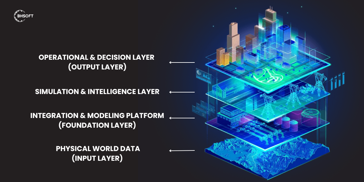
How Urban Digital Twins Work
An Urban Digital Twin operates as a multi-layered, data-driven ecosystem that continuously mirrors and analyzes the physical city.
Data Collection From the Physical World
Every Urban Digital Twin starts with raw, real-world data. This data is captured from a wide range of urban sources to ensure both accuracy and context. Common inputs include:
IoT sensors: traffic flow, air quality, noise levels, water usage, power meters
Smart infrastructure systems: HVAC controls, energy grids, EV charging networks, mobility systems
City operations and public services: transit schedules, emergency response systems, waste collection routes
External and third-party sources: satellite imagery, weather APIs, GIS basemaps, mobile network usage patterns
The richer the data, the more reliable and actionable the Urban Digital Twin becomes.
Platform Integration and Modeling
Once collected, this diverse data must be processed, aligned, and mapped within a centralized platform. Modern Urban Digital Twin systems rely on cloud-based architectures capable of fusing multiple datasets into a unified digital environment.
This integration typically includes:
- GIS layers for spatial accuracy
- 3D/4D models for visually representing buildings, terrain, and infrastructure
- Structured databases for system relationships
Semantic ontologies—such as RealEstateCore for built environments or NGSI-LD for smart city data models—to standardize how assets, sensors, and services interact
Semantic modeling is especially important. It helps the system understand that a specific “temperature sensor” belongs to a room, which is part of a building, which serves a hospital. This contextual intelligence makes AI and analytics significantly more precise and meaningful.
Platforms commonly used for this layer include Azure Digital Twins, TwinWorX, Esri ArcGIS, and Bentley iTwin.
Simulation and Scenario Testing
Then, cities can begin to run “what-if” simulations that explore outcomes before implementing real-world changes. Using AI, machine learning, and predictive physics-based modeling, Urban Digital Twins help cities test:
- Infrastructure upgrades
- Traffic and mobility adjustments
- Energy consumption patterns
- Flood risks, climate impacts, or heat waves
- Emergency evacuation scenarios
- Zoning changes or new development proposals
Real-Time Control and Feedback Loops
Advanced Urban Digital Twin systems also support continuous monitoring and real-time operational control.
Here’s how this works:
- The twin detects anomalies (e.g., unexpected energy spikes).
- It alerts operators through dashboards or automated notifications.
In more sophisticated systems, AI can automatically adjust settings—like reducing HVAC loads or rerouting traffic—without human intervention.
For example, platforms such as TwinWorX can autonomously adjust building systems based on machine learning models trained on historical and real-time performance data.
Read more: Applications And Importance Of BIM Technology
Key Benefits of Urban Digital Twins for Modern Cities
Urban Digital Twins are delivering measurable impact in cities worldwide. Here’s how they create value across planning, operations, sustainability, and public safety.
Smarter, Faster Urban Planning
UDT enable cities to run accurate simulations, reducing guesswork and political bottlenecks. By visualizing impacts before implementation, planners can align stakeholders more easily and accelerate approvals.
According to Deloitte, cities using digital twins achieve project approvals up to 25% faster, with significantly improved collaboration among departments.
Reduced Infrastructure Risk
Predictive maintenance powered by real-time data allows cities to detect issues early—before they escalate into costly failures.
Public-sector case studies show 10–30% savings when shifting from emergency repairs to planned maintenance, extending asset lifecycles and reducing downtime.
More Sustainable, Low-Carbon Cities
UDT play a central role in climate action. They support emissions monitoring, energy optimization, and environmental scenario modeling.
Cities are already using them to:
Optimize street lighting schedules
Balance electric grid loads
Simulate green building retrofits
Improve water and waste management efficiency
Stronger Emergency Preparedness and Response
Digital twins allow cities to simulate natural disasters, fire behavior, flood risks, and transit rerouting to improve crisis readiness.
In Boston, the city’s digital twin has been used to model coastal flooding scenarios, improving evacuation strategies and reducing emergency response times.
Unified, Cross-Department Operations
Instead of managing siloed systems, departments can collaborate through a single, integrated platform.
Solutions like TwinWorX provide a unified 3D operational view, helping planners, engineers, and field operators work from the same real-time data.
Enhanced Citizen Experience (bổ sung quan trọng)
By analyzing mobility patterns, service usage, and environmental conditions, governments can:
Optimize public transit routes
Improve walkability and accessibility
Reduce noise, pollution, and heat islands
Plan better public spaces
This results in higher quality of life and greater resident satisfaction.
Improved Investment and Policy Decisions (bổ sung)
With accurate forecasting and ROI modeling, cities can prioritize projects that deliver the highest impact. Digital twins allow policymakers to test outcomes of zoning changes, tax incentives, infrastructure investments, or sustainability regulations.
Urban Digital Twin vs. Traditional GIS Systems: What’s the Difference?
|
Feature |
Traditional GIS Systems |
Urban Digital Twins (UDT) |
|
Data Type |
Primarily static spatial data and maps |
Dynamic, real-time data continuously updated |
|
Purpose |
Mapping, spatial analysis, visualization |
Simulation, prediction, and optimization of city operations |
|
Data Refresh |
Periodic updates, not real time |
Live data ingestion from IoT, sensors, and city systems |
|
Interaction |
One-directional: users query and analyze |
Two-directional: system analyzes, simulates, and responds |
|
Context Awareness |
Limited to location and basic attributes |
Multi-layer contextual awareness (sensor → room → building → city system) |
|
Scenario Testing |
Limited, often static simulations |
Real-time, multi-scenario “what-if” simulations |
|
System Integration |
Restricted, mostly map-based datasets |
Deep integration across traffic, energy, utilities, environment, and public services |
|
Output |
Maps, spatial insights |
Predictions, optimizations, and real-time operational control |
Learn more: GIS mapping services
Challenges & Limitations Of Urban Digital Twins
Urban Digital Twins offer transformative potential, but they are not a universal fix. As cities push toward more connected and data-driven infrastructure, several practical challenges often slow adoption.
Fragmented Data and Legacy Systems
Many cities still rely on outdated infrastructure and siloed departmental platforms. Data is often incomplete or incompatible, making integration difficult.
Because UDTs rely on seamless data flows, poor integration can undermine the model’s accuracy and value.
Privacy and Data Ethics
UDTs collect large volumes of real-time data related to mobility, utilities, and public services. Without strong policies around consent, anonymization, and data governance, the risk of misuse or surveillance increases.
Robust privacy frameworks are essential—not optional.
High Upfront Investment
Building an Urban Digital Twin requires sensors, cloud infrastructure, 3D models, skilled personnel, and ongoing maintenance.
While long-term ROI can be substantial, the initial cost is a major barrier, especially for budget-constrained municipalities.
Interoperability and Vendor Lock-in
With no universal standards, platforms and data models vary widely across vendors. This creates challenges when integrating systems or switching providers later.
Although open standards are emerging, most cities still operate in fragmented digital ecosystems.
Skills and Workforce Gaps
Municipal teams often lack expertise in data engineering, simulation, AI, or systems architecture. Even with the right tools, cities may underuse their UDT because staff do not know how to interpret or maintain the system.
Without proper training or long-term partners, the twin risks becoming a static dashboard.
Cybersecurity Risks
As UDTs integrate critical infrastructure—transportation, utilities, public safety—the attack surface for cyber threats expands.
Cities must invest in strong cybersecurity measures to avoid breaches that could compromise sensitive data or operations.
Scalability Challenges
Pilot UDTs often work well at the district level but become harder to scale citywide due to data volume, system complexity, and coordination across multiple agencies.
How Urban Digital Twins Will Shape the Future of Smart Cities
Autonomous City Operations
Urban Digital Twins will enable cities to automate complex operations with minimal human intervention. Autonomous traffic management systems can optimize signals, reduce congestion, and reroute vehicles in real time. At the same time, infrastructure equipped with sensors and AI will automatically detect issues—such as leaks, outages, or equipment failures—and trigger corrective actions without waiting for manual reporting.
Climate Adaptation & Resilience
Future-ready cities will rely on UDTs to model climate scenarios such as heatwaves, flooding, or sea-level rise—projecting impacts for 2030, 2050, and beyond. These insights help planners design green infrastructure, expand urban tree coverage, and optimize water and energy systems to build stronger climate resilience.
AI-Driven Policy Making
Instead of relying solely on historical data, governments can use AI-driven simulations to test zoning changes, mobility policies, and environmental regulations before implementation. This “simulate-before-you-implement” approach reduces risks, improves outcomes, and ensures policies deliver measurable results.
Conclusion
Urban Digital Twins are rapidly becoming the backbone of modern smart city strategy. By simulating traffic, utilities, climate impacts, and emergency scenarios before changes are made, Urban Digital Twins help cities operate more efficiently, sustainably, and resiliently.
At BHSOFT, we support this transformation with tailored Smart City Solutions including digital twin development, IoT data integration, real-time analytics platforms, GIS & 3D mapping services, and AI-powered simulation tools that help cities plan, monitor, and optimize urban systems.
Ready to bring your city into the digital twin era? Contact us today to start your smart city journey with BHSOFT.