Quynh Ngoc Pham
Content Manager
Home > Insigh> Technology
Drone Mapping: A Comprehensive Guide
5 minutes read
Audio description available
December 10, 2024
Manual data collection and analysis are quickly becoming outdated. Gone are the days of relying solely on manual surveys or costly satellite imagery. With drone mapping, companies can now gather real-time geospatial data efficiently and accurately. This cutting-edge technology is already transforming industries such as construction, agriculture, and environmental management.
In this article, we’ll explore the fundamentals of drone mapping, its key benefits, how it can boost your business, and why custom solutions are essential to fully leverage this technology. Let’s dive in!
What Is Drone Mapping?
Imagine: You’re a construction manager overseeing a massive project, and you need to survey the land, monitor progress, and track resources. Traditionally, this would mean scheduling surveyors, waiting days for reports, and making costly adjustments on-site. Now, imagine getting all of that information—accurately, in real-time, and with just the push of a button. That’s drone mapping in action.
Drone mapping refers to the process of using unmanned aerial vehicles (UAVs), or drones, equipped with specialized cameras and sensors to gather geospatial data. This data is then processed into maps, 3D models, and other visual assets that provide accurate, detailed insights into the land or environment being surveyed.
Drone mapping allows businesses to create real-time models, visualize landscapes, and monitor changes across large areas without the costs and time associated with traditional survey methods.
Unlike manual surveys, aerial survey technology can cover vast areas quickly, gathering high-precision data with minimal disruption to the environment. The results are delivered fast, with minimal manpower, and offer data that can be updated remotely as often as needed. In industries where accuracy and speed are key, such as construction, agriculture, and mining, drones are already changing the game.
According to a report by Droneii, UAV mapping and surveying continues to be the leading application for drones worldwide and is projected to remain so in the future.
Read also: What Is 3D Mapping And What Is It Used For
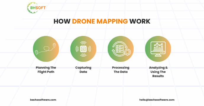
How Drone Mapping Work
At its core, drone mapping uses UAV technology to collect accurate, actionable geospatial data from the air. The workflow is streamlined and highly efficient, typically consisting of four key stages.
1. Flight Planning
Drone mapping begins with flight planning using specialized drone mapping software. Operators define the survey area and configure parameters such as altitude, image resolution, and overlap. These settings ensure complete coverage and data accuracy. Once configured, the drone follows the pre-planned route autonomously.
2. Data Capture
During the flight, the drone captures data using high-resolution cameras or advanced sensors. Photogrammetry-based drone mapping collects overlapping, GPS-tagged images from multiple angles. For elevation-intensive projects, LiDAR drone mapping is used to generate precise terrain data, even in dense vegetation. Thermal and multispectral sensors support applications such as infrastructure inspection and vegetation analysis.
3. Data Processing
After data collection, aerial data is processed using professional drone mapping and GIS software. Photogrammetry software stitches images into 2D orthomosaic maps and 3D models, while LiDAR data is converted into dense point clouds. Calibration and alignment ensure high spatial accuracy and reliable outputs.
4. Analysis and Application
The final drone mapping outputs are integrated into GIS platforms for analysis. Users can measure distance, area, volume, and elevation, or overlay drone data with other spatial datasets. This enables informed decision-making across industries such as construction, agriculture, environmental monitoring, and urban planning.
Learn more: Low-Code Development Services
Why Drone Mapping Works Better Than Traditional Methods
Drone mapping is faster, more accurate, and cost-effective compared to traditional surveying methods. Drones can map large areas in just hours, while manual surveys often take days or weeks. Their high-resolution cameras and LiDAR sensors provide centimeter-level accuracy, minimizing errors common with traditional tools.
Using drones reduces costs by eliminating the need for large survey teams and expensive equipment. Drones also improve safety by collecting data remotely, keeping workers out of hazardous environments. With their ability to capture 3D models, elevation maps, and thermal imagery, drones offer unmatched versatility. Traditional methods simply can’t compete with the speed, precision, and efficiency of drone mapping.
Applications Of Drone Mapping In Key Industries
Drone mapping has become a critical solution for organizations that require fast, accurate, and scalable geospatial data. By using UAVs, businesses can capture high-resolution aerial data much faster than traditional surveying methods, enabling real-time, data-driven decisions while improving efficiency, reducing costs, and enhancing safety.
When integrated with GIS platforms, drone mapping services deliver even greater value by supporting precise topographic mapping, volumetric analysis, environmental monitoring, and asset inspection. This ability to quickly capture and analyze spatial data has made UAV drone mapping a core component of modern digital transformation across industries.
Construction and Infrastructure
The construction and infrastructure sectors are leading adopters of drone mapping for construction projects. UAV drone mapping allows teams to conduct accurate site surveys, monitor progress in real time, and manage risks more effectively throughout the project lifecycle.
By using drone mapping services, construction companies can generate aerial imagery, orthomosaics, and 3D site models to assess terrain, track milestones, calculate stockpile volumes, and identify safety issues—significantly reducing the need for manual surveys.
As a result, drone mapping helps construction firms accelerate project delivery, minimize delays, improve accuracy, and lower operational costs while maintaining safety and regulatory compliance.
Agriculture and Precision Farming
Drone mapping for precision farming is transforming how farmers manage crops and resources. UAVs equipped with multispectral, RGB, and thermal sensors enable accurate monitoring of crop health, irrigation efficiency, and soil conditions.
Drone mapping applications in agriculture deliver actionable insights for variable-rate fertilization, targeted pest control, and optimized irrigation. By focusing on specific problem areas rather than entire fields, farmers can reduce waste, lower input costs, and improve yields.
As a result, drone mapping services help agribusinesses increase productivity, enhance resource efficiency, and maintain healthier crops.
Environmental Monitoring and Conservation
Environmental agencies and conservation organizations increasingly rely on UAV drone mapping for environmental monitoring. Drones offer a cost-effective and non-intrusive way to collect high-quality data across large and remote areas.
Drone mapping is widely used for monitoring forest health, tracking wildlife habitats, assessing coastal erosion, and evaluating land-use changes. Compared to traditional field surveys, UAV drone mapping significantly reduces data collection time while improving spatial accuracy.
These detailed aerial maps and 3D models support evidence-based decision-making in conservation planning, climate impact assessments, and sustainable land management initiatives.
Energy and Utilities
Environmental agencies and conservation organizations increasingly use UAV drone mapping for environmental monitoring to collect accurate data across large and hard-to-reach areas in a cost-effective and non-intrusive way.
Drone mapping supports forest health analysis, wildlife habitat tracking, coastal erosion assessment, and land-use change detection. Compared to traditional surveys, UAV drone mapping delivers faster data collection with higher spatial accuracy.
As a result, detailed aerial maps and 3D models enable data-driven decisions for conservation planning, climate impact studies, and sustainable land management.
Real Estate and Urban Planning
Drone mapping for real estate and urban planning provides accurate spatial data to support smarter development decisions. Developers use drone-generated aerial imagery and 3D models to assess land suitability, visualize projects, and improve property marketing.
When combined with GIS, UAV drone mapping enables urban planners and architects to build digital city models for evaluating zoning impact, traffic flow, environmental constraints, and infrastructure capacity before construction.
As a result, drone mapping services help stakeholders reduce risks, plan more efficiently, and support sustainable urban development.
Insurance and Property Inspection
The insurance industry increasingly uses drone mapping for property inspection and claims assessment to evaluate damage quickly, safely, and accurately after disasters or structural incidents.
Drone mapping services provide high-resolution imagery, precise measurements, and georeferenced data, enabling faster claims processing and more reliable risk assessments—especially for rooftops, large properties, and hazardous areas.
As a result, UAV drone mapping helps insurers reduce inspection costs, improve assessment accuracy, and enhance overall customer satisfaction.
Why Drone Mapping Is a Strategic Advantage
Drone mapping applications deliver clear business value across industries by combining speed, accuracy, and scalability. When integrated with GIS and advanced analytics, UAV drone mapping supports better operational insight, risk reduction, and data-driven planning.
As drone technology and regulations continue to evolve, drone mapping services are becoming a strategic enabler of efficiency, sustainability, and innovation worldwide.
Off-the-Shelf vs. Custom Drone Mapping Software: What’s Best for Your Business?
In 2026, the effectiveness of drone mapping depends heavily on software capabilities. Businesses typically choose between off-the-shelf drone mapping software and custom drone mapping solutions, based on their operational complexity.
Off-the-shelf solutions are affordable and quick to deploy, offering basic features such as 2D maps and simple 3D models. However, they often lack flexibility, advanced analytics, and deep GIS or sensor integration
Custom drone mapping software is built for specific industry needs and supports advanced sensors like LiDAR, thermal, and multispectral cameras, along with AI-driven analysis. This adaptability enables higher accuracy, seamless workflow integration, and measurable gains—often improving operational efficiency by 20–30%.
While off-the-shelf tools may suit basic use cases, custom drone mapping software is the strategic choice in 2026 for businesses that require precision, scalability, and long-term performance.
Why Choose Us?
At BHSOFT, we specialize in custom drone mapping software tailored to your specific needs. With our expertise in GIS solutions and drone technology, we create solutions that seamlessly integrate with your current systems, ensuring smoother operations. Whether you need precise 3D mapping, advanced data analytics, or real-time monitoring, our team builds solutions that make your data work harder for you.
We understand the challenges different industries face, and our team takes the time to develop software that directly addresses these pain points. Plus, we offer continuous support to ensure your solution evolves as your needs grow.
Contact us today for a demo or free consultation and discover how we can help you maximize the potential of drone mapping technology.