In 2D GIS (Geographic Information System) world, vector tile is an important concept for mapping. This article will introduce to you the general definition of vector tile and the reason why it is the next generation of tiled maps.
Introduction to vector tiles
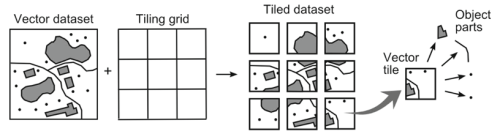
People have been familiar with the raster tile concept. With raster tile, the map is illustrated by a set of squared images placed next to each other, each with a fixed geographical area and scale. Vector tiles, which were introduced later also divide data into square. The difference is that there is no raster image, instead, pre-generated vector data are present on the requested area. These vector data are vector representation of the features in the tile.
Strengths of vector tiles over raster tiles
Vector tiles store and deliver geographic data in small chunks to a browser or other client application. The client is able to use a predefined set of styling rules to draw tiles of raw vector coordinate and attributes data sent by the server. This allows users to directly restyle data on the fly with minimum resources.
To illustrate this better, let’s take an example:
You would like to change the shade of green used to draw parks. With raster tiles, you are obliged to rebuild every tile containing a park. With vector tile, all you have to do is to update your styling instruction in one place and the tiles themselves stay the same.
A more detailed list of best advantages of using vector tile:
- Smaller size data, thus, faster data transfer and lower bandwidth consumption.
For example, when you implement an app which contains a map, you have to work with a lot of huge feature files such as geoJSON. Sometimes it is too big to handle. That’s when vector tiles come to the rescue. You can absolutely upload your huge file of geoJSON to Mapbox service to convert it to vector tiles which are much smaller in size but a lot easier to handle with while still offers high resolution and efficient caching.
- Better user experience
- Clients can directly render maps, not by the server.
- The pre-defined style allows easy customization with one small text file. User can decide the appearance of the map, map font, map labels language as well as the option to show/ hide map elements directly on-the-fly.
- The client has access to actual feature information (attributes and geometry), thus, possible to render highly sophisticated details.
- Very smooth zooming
- Fast generating time
- Both desktop and mobile friendly
- Supported by many Open Source JavaScript libraries:
Hope this article helps you understand better about vector tiles. Currently at BHSoft we are super excited about the approach of applying vector tiles in our work and we have already tried it in many projects. We have had tons of experience of working with Open Layers, Google Map APIs, Leaflet and Mapbox. BHSoft invests very well in our tech infrastructure to power better for all of our services. We are always open to new projects and opportunities.
Check out our projects here and stay tuned for more great news from BHSoft.