If a customer asks for Equal Earth, what should a GIS team evaluate?
10 minutes read
September 23, 2026
If a customer requests Equal Earth or any projection outside the application's current default, the team should first understand why.
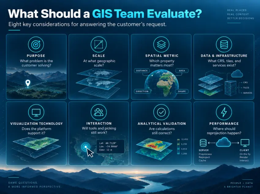
A useful evaluation process could look like this:
1. Purpose
What problem is the customer trying to solve?
Is the application:
- a global environmental dashboard?
- a thematic statistical visualization?
- a monitoring platform?
- an educational map?
- a decision-support system?
- The projection requirement should connect to a real user need.
2. Scale
Is the user working at:
- global scale?
- regional scale?
- national scale?
- city scale?
- individual infrastructure asset scale?
Equal Earth is primarily relevant to world-scale representation.
A different CRS may be more appropriate once the application moves into detailed local workflows.
3. Spatial metric
What properties need to remain meaningful?
For example:
- area
- distance
- direction
- shape
- topology
- elevation
- volume
This is one of the most important questions because no single 2D projection preserves all of them.
4. Existing data and infrastructure
The team should inspect:
- source CRS
- spatial databases
- GIS services
- vector tiles
- raster tiles
- map servers
- APIs
- third-party basemaps
- spatial analysis pipelines
A projection requirement can expose assumptions that were previously hidden inside the system.
5. Visualization technology
Does the chosen mapping framework support Equal Earth directly?
If not, can it support:
- custom projections?
- reprojection through libraries such as PROJ?
- projected vector tiles?
- server-side rendering?
- custom shaders or geometry transformations?
Technology selection should follow the requirement rather than determine it prematurely.
6. Interaction
The team should test whether common GIS interactions continue to work correctly:
- click and identify
- feature selection
- coordinate inspection
- drawing
- editing
- measurement
- clustering
- labels
- overlays
- spatial queries
Visual correctness alone is not enough.
7. Analytical validation
Measurements and spatial calculations must be validated independently from the rendering.
For example, displaying an equal-area map does not automatically mean every spatial operation should be performed directly in that projected coordinate space.
The analytical model and the visual model may need to remain separate.
8. Performance
Finally, the team needs to determine where reprojection should happen and how it affects:
- client performance
- server workload
- tile generation
- caching
- network bandwidth
- application responsiveness
Only after these questions are understood should the technical implementation be selected.
A useful framework for GIS representation decisions
This leads to a simple way of thinking about GIS architecture:
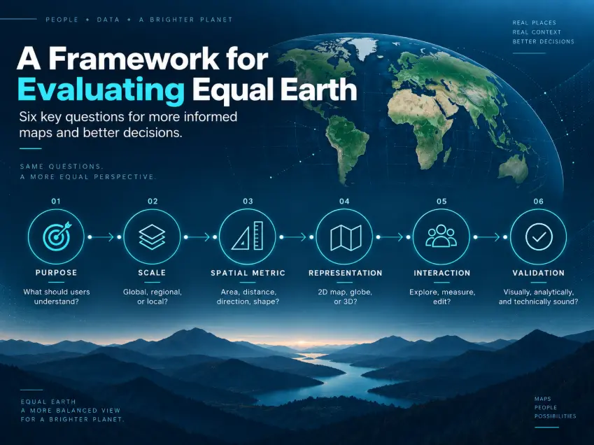
Purpose → Scale → Spatial Metric → Representation → Interaction → Validation
- Purpose: What decision is the user trying to make?
- Scale: Is the application global, regional, local, or asset-level?
- Spatial Metric: What needs to remain meaningful: area, distance, direction, shape, elevation, or another property?
- Representation: Should the information be shown through a 2D projected map, equal-area world map, 3D globe, terrain environment, or Digital Twin?
- Interaction: How will the user explore, measure, edit, or analyze the information?
- Validation: Does the representation remain visually correct, analytically correct, and performant for the intended workflow?
This moves projection choice away from being an isolated cartographic decision.
It becomes part of GIS product design and system architecture.
How this connects to the GIS work we do at BHSOFT
This way of thinking is closely related to the GIS projects we work on at BHSOFT.
Our GIS work already involves different types of spatial representation depending on the customer problem.
In map-centric applications, interactive 2D GIS can provide the clearest and most efficient environment for working with infrastructure, assets, geographic layers, and operational information.
In other projects, the problem requires a three-dimensional spatial context.
Our experience in 3D GIS and Digital Twin solutions includes areas such as:
- large-scale geospatial datasets
- terrain
- 3D visualization
- spatial interaction
- BIM-related information
- Cesium
- 3D Tiles
- geospatial system integration
The common principle is not that every project should become 3D. It is the opposite.
The representation should follow the customer's problem.
For one customer, the right answer may be a traditional interactive 2D map.
For another, it may be Equal Earth for a global analytical dashboard.
For another, a globe may communicate global relationships more effectively.
And for infrastructure, construction, or urban systems, the right representation may be a 3D GIS environment or Digital Twin.
What Equal Earth means for our adaptability as a GIS team
Equal Earth is therefore useful not only as another map projection to learn.
It is also a practical test of how flexible a GIS architecture and engineering team really are.
A GIS platform that assumes:
- one projection
- one tile system
- one renderer
- one type of interaction
- one visualization model
can become difficult to adapt when customer requirements change.
A more flexible architecture separates concerns such as:
data storage → coordinate reference systems and transformation → spatial services and processing → visualization → interaction → business logic
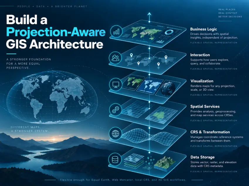
That makes it easier to introduce another representation without redesigning the entire application.
For the GIS team, adaptability therefore means more than knowing how to configure Equal Earth.
It means understanding:
- why a customer would need it
- which parts of the current platform are affected
- which assumptions need to change
- which components can remain reusable
- how spatial accuracy should be validated
- and how the new representation fits the customer's actual workflow
This is the more valuable engineering capability.
The future of GIS is not one projection
Equal Earth is a useful reminder that there is no single way to represent geographic information.
Sometimes users need a global thematic map where relative area matters.
Sometimes they need an operational 2D GIS system.
Sometimes they need a globe.
Sometimes they need terrain, buildings, infrastructure, and BIM information in three dimensions.
The progression may look like:
Global Analysis → 2D Operational Mapping → 3D GIS → Digital Twin
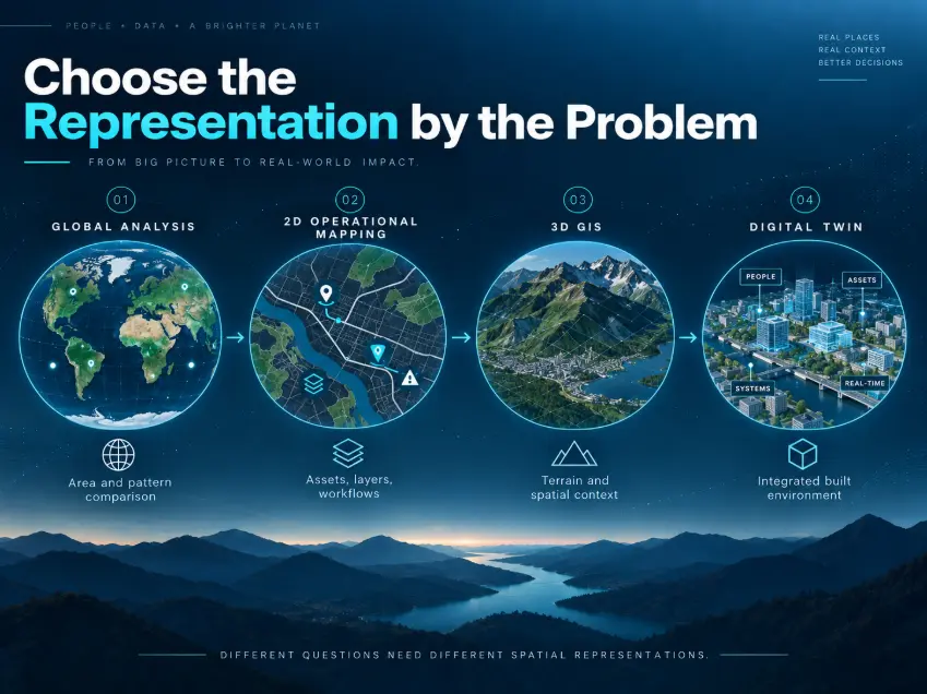
But these should not be viewed as replacement technologies.
They are different tools for understanding different spatial problems.
For GIS engineering teams, learning new projections such as Equal Earth is valuable.
Building systems that can adapt to different spatial representations is even more valuable.
At BHSoft, this is the capability we continue to develop: combining GIS engineering, modern visualization technologies, spatial data processing, 3D geospatial platforms, and flexible software architecture to build solutions around the customer's real spatial problem — rather than around a single mapping technology.
Because sometimes innovation in GIS does not come from collecting more data.
It comes from finding a better way to represent, interact with, and understand the data we already have.
Explore More from BHSoft
3D City Visualization with Cesium
How BHSoft Created a Digital Twin with CesiumJS
Urban Planning with GIS: From Data to Smarter Decisions
3D GIS & Digital Twin Solutions
Is your GIS platform ready for changing spatial requirements?
Supporting a new projection can affect much more than the map renderer. It may require changes across data processing, coordinate transformation, visualization, interaction, spatial analysis, and performance.
BHSOFT works with businesses to build flexible GIS platforms that can adapt to different coordinate systems, visualization models, and customer workflows.
Your project requires a custom GIS, WebGIS, 3D GIS, or projection-aware mapping solution?
Talk to our team about the right approach for your project.