
Ngoc Nguyen
SEO Engineer
Home > Insight > Technology
IoT and Real-Time Sensors: The Key to Proactive Urban Flood Management in Vietnam
5 minutes read
Audio description available
June 11, 2026
Flooding from heavy rain, high tides, and rapid urbanization is a chronic nightmare for Vietnamese megacities like Ho Chi Minh City and Hanoi. Traditional responses—such as elevating roads, building dykes, or manually operating pumps—are highly capital-intensive and inherently reactive, crippled by a total lack of real-time forecasting data.
Rapid urban growth has paved over natural drainage, replacing soil with impervious surfaces that overwhelm aging infrastructure. Combined with rising sea levels and unpredictable rainfall, flooding has become a critical roadblock for Vietnam’s smart city agenda. The core challenge is no longer just about moving water faster; it is about collecting real-time data across thousands of locations to make actionable decisions before disaster strikes.
As Vietnam’s digital transformation strategy enters a mature phase, the integration of IoT and smart sensor networks offers a game-changing solution. This technology successfully shifts the urban paradigm from costly, reactive damage control to cost-optimized, proactive flood management.
Read more: Renewable Energy and Smart Grids
1. The Architecture of a Smart IoT Flood Management System
To run an intelligent flood management ecosystem, the underlying technology framework is built systematically across three core layers:
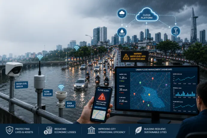
The Sensor Layer (Data Collection)
Hardware devices are strategically
deployed at critical chokepoints. Ultrasonic or radar water level sensors are
installed over canals and inside manholes to measure water depth without direct
physical contact. Flow sensors are placed inside drainage pipes to monitor
velocity, while a grid of automated rain gauges continuously updates rainfall
data at a micro-climate level.
The Transmission Layer (Network Connectivity)
During severe storms, standard cellular networks often face severe congestion. Therefore, the system prioritizes Low-Power Wide-Area Networks (LPWAN) such as LoRaWAN or NB-IoT (Narrowband IoT), both of which are increasingly supported by Vietnamese telecom operators. These networks ensure continuous, stable data transmission from deep underground or remote sites with minimal battery consumption.
The Central Processing Layer (Cloud & AI)
Raw data is streamed into a centralized cloud platform. Here, Machine Learning (ML) algorithms analyze rainfall patterns, flow dynamics, and tidal variations to generate predictive flooding scenarios for the hours ahead.
Moving Beyond Basic Monitoring
Advanced AI models can now identify hidden patterns across historical rainfall records, drainage performance, and tidal conditions. These predictive analytics capabilities enable city operators to forecast potential flooding hotspots from 30 minutes to several hours before water levels become critical, providing valuable time to activate mitigation measures and notify affected communities.
Furthermore, as GeoAI technologies continue to mature, combining artificial intelligence with geospatial analysis dramatically improves the accuracy of flood prediction and resource allocation.
Read more: How GIS software supports urban asset management
2. Practical Applications for Vietnam’s Urban Landscape
In Vietnam, this technology directly solves two critical urban pain points: protecting commuters on the move and automating infrastructure response.
Early Warning Systems for Citizens
Instead of discovering a road is flooded only after their motorbikes stall, citizens get real-time insights. Data from flood sensors integrates directly into municipal apps (like iHanoi or HCMC Digital Citizen), Zalo mini-apps, and digital maps (Google Maps, Vietmap).
When water levels breach safe thresholds (e.g., 20 cm for motorcycles), the system pushes geo-targeted notifications to nearby commuters, suggesting alternative routes to minimize engine damage and gridlock.
On the backend, integrating this data with GIS-based dashboards allows municipal operators to visualize flood zones on a live map. Compared to traditional tabular data, this geospatial context gives authorities immediate situational awareness to safeguard critical infrastructure, schools, and evacuation routes.
Automated Drainage Infrastructure (Smart Actuation)
Smart actuation eliminates human delay. When sensors at structural bottlenecks detect that internal pipe levels have breached capacity, control signals automatically trigger heavy-duty pump stations to accelerate drainage.
Simultaneously, smart tidal gates automatically open or close based on pressure and water level differentials measured on both sides of the dyke, instantly blocking river backflow into low-lying city streets.
Looking ahead, these systems lay the groundwork for Digital Twin environments. By feeding real-time sensor data into a virtual model of the city's infrastructure, authorities can simulate heavy rainfall and tidal events to stress-test response strategies before deploying them in the real world.
3. Real-World Challenges to Overcome
While the technological outlook is highly promising, scaling a municipal IoT network for flood control in Vietnam requires overcoming four major operational roadblocks:
Harsh Operating Environments
Urban drainage systems in Vietnam are notoriously punishing, filled with heavy solid waste, near-100% humidity, and corrosive chemicals. To survive without causing prohibitive maintenance costs, underground IoT hardware requires specialized IP68-rated protection and rugged, anti-clogging designs.
Data Fragmentation
Hydro-meteorological data, drainage company pump operations, and municipal Intelligent Operation Centers (IOCs) frequently operate in silos. Standardizing secure, cross-departmental API connections remains a critical administrative and technical hurdle.
Power Optimization
Because underground and canal sensors cannot access the electrical grid, battery longevity is paramount. Engineers must design ultra-efficient edge algorithms that keep devices in low-power sleep modes during dry periods, only "waking up" to transmit high-frequency telemetry during active rainfall to achieve a viable 3-to-5-year lifespan.
Cybersecurity and Data Protection
As flood monitoring systems integrate directly with critical infrastructure (like automated pump stations and tidal gates), they become potential targets. Implementing secure communication protocols, strict end-to-end device authentication, encrypted data transmission, and continuous network monitoring is essential to prevent unauthorized access that could sabotage emergency operations.
Conclusion
IoT and real-time sensors are not a standalone cure for urban flooding, but they are the smartest tools available for climate adaptation in Vietnam. By automating data transparency, this technology directly minimizes economic losses, protects citizen assets, and delivers a clear long-term return on investment through reduced emergency costs and minimized traffic disruptions.
As Vietnam accelerates its smart city initiatives, the convergence of IoT, GIS, AI, and Digital Twins will play a pivotal role in building resilient, climate-adaptive urban environments.
Partner with bHSoft for Smart City Excellence
At BHSoft, we turn these complex urban challenges into scalable technological realities. With deep expertise in Smart City solutions, IoT integration, and GIS data processing, we help municipalities and enterprises build robust software architectures that power tomorrow's environments. From optimizing sensor data ingestion to developing intuitive, citizen-facing applications, bHSoft engineers sustainable digital ecosystems tailored to the unique dynamics of Vietnam and the global market.