GIS In Urban Planning: Benefits, Applications and Use
The process of urban planning is multi-faceted. Finding the ideal balance between development, manufacturing, cities and housing, services, and income inequality aids in building better communities. GIS is the backbone in urban planning, enabling the creation of a living for all people from all socioeconomic backgrounds.
GIS and Urban planning definition
Urban planning, as mentioned before, is the process of creating and designing open spaces, urban areas, and the built environment. Urban planning is a complex process that involves infrastructure, utility systems, communication networks, supply chains, and more.
GIS, or Geographical Information System, is software that helps experts collect, handle, analyze, and graphically represent massive amounts of geospatial data. In urban planning, GIS allows planners to focus efforts on growth areas and opportunities. On the other hand, it also allows them to direct investments in infrastructure and services like transportation, utilities, and schools.
Benefits of GIS in Urban planning
There are numerous benefits of using GIS in urban planning, but here are the top five.
Improve mapping
GIS can reduce data storage costs, enhance the effectiveness of thematic mapping, and boost the credibility of maps (how current they are). This is possible because all of a region’s maps and data can be stored in a single location.
Increase access to vital information
GIS simplifies the process of collecting, organizing, and retrieving information from a wide range of sources. Similar to conventional GIS, cloud-based GIS offers this benefit in addition to enabling data viewing from any mobile device.
Increase quality and efficiency of public services
By building a public-facing portal with GIS, the public and government agencies can share information more easily. Public access to the information they require and quick information sharing between government officials and the general public.
Increase support for strategic decision making
Planners are better able to develop well-informed strategies and more quickly access a wider range of essential geographic data. Moreover, they can also think about a wider range of “what-if” scenarios, which ought to aid them in creating stronger, longer-term plans.
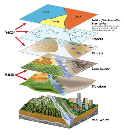
GIS applications in urban planning
GIS has a number of tools in urban planning. Among the most widely applicable are database management, visualization, spatial analysis, and spatial modeling.
Database management
Database management is the process of creation, import, upkeep, and use of every piece of data moving into and out of a GIS platform.
Urban planning, as you may know, entails the storage of socioeconomic data, land use maps, and plans. This contains enormous amounts of data in numerous formats. With the help of GIS, all of that data can be stored and conveniently organized in a single database. Urban planners can use spatial queries to quickly access data once it has been added to the database.
Visualization
In the context of urban planning, visualization often refers to maps. GIS provides strong mapping visualization tools that let planners create maps in both 2D and 3D. Environmental and socioeconomic data can be added as a secondary data source or used as a tool to assist in the creation of these maps.
Urban planners can explore options and make decisions more easily when using digital maps.
Spatial analysis & modeling
GIS in urban planning enables spatial modeling and analysis, which can support numerous important urban planning tasks. These duties include picking a location, analyzing the suitability of the land, modeling land use and transportation, identifying planning action areas, and conducting impact analyses.
Urban planners can complete these tasks with the aid of GIS features like interpolation, buffering, map overlay, and connectivity measurement.
Uses of GIS in urban planning
Resource Inventory
Urban planning requires the gathering of data on environmental conditions and land use. Because users must manually enter the data even when using a single computer, this typically takes a lot of time. Utilizing GIS and remote sensing aids in the timely gathering of environmental and land use data. The aforementioned methods are used to identify land use and any potential changes in urban areas. It can also be used to create compelling visualizations with 3D CAD models.
Creating land-use maps & plans
Future land-use maps serve as a community’s roadmap for upcoming construction projects, infrastructure plans, and public areas. These maps make sure that a city’s urban planning takes into consideration issues like pollution control, limiting urban sprawl, environmental preservation, and mitigating transportation problems.
Using GIS, urban planners can quickly map out the current state of the city and then explore potential futures using various modeling and predictive data techniques. Making a thoughtful, sustainable, and sound future land-use map using this exercise would be ideal.
Analyzing socioeconomic & environmental data
GIS enables the creation of thematic maps i.e. maps that combine data and location to explore correlation and display trends.
Users can create layered images that include topography, street maps, thematic maps, and more using the various data sets stored in the GIS database. This makes it simple to spot conflict-prone areas as well as ideal spaces.
Land suitability analysis/site selection
Urban planners can perform land suitability analysis, a crucial stage in site selection, using GIS tools like map overlay.
Urban planners can identify environmentally sensitive areas with the aid of remote sensing, spatial queries, and environmental data analysis. They can spot any areas where potential development would conflict with the environment by superimposing existing land development on maps of land suitability.
Final thought
Using GIS, urban planners can better develop the towns and cities where we live, plan for new construction, and make adjustments as the local population shifts. When it comes to efficient urban planning, GIS is a crucial and practical tool that has become priceless for many.
BHSoft helps businesses in using, creating, and disseminating GIS in urban planning more successfully. Our
Contact us and build your own solutions today!