Real-Time GIS in Logistics: From GPS Data to Smarter Dispatch Decisions
15 minutes read
November 17, 2026
Imagine a logistics dispatcher overseeing vehicles across multiple delivery zones.
The dashboard shows every vehicle on a map. Each marker represents a truck, its latest reported location, and perhaps its current speed.
At first glance, the operation appears fully visible.
But what happens when a vehicle approaches a delayed delivery? Can the system identify the risk before the customer complains? Does it know when a vehicle enters a warehouse? Can dispatchers distinguish a temporary GPS error from an actual route deviation?
These questions expose the difference between location tracking and location intelligence.
A basic tracking system answers:
Where was this vehicle last reported?
A real-time GIS platform can go further:
What does that location mean for the operation, and what action should follow?
This is where real-time Geographic Information Systems (GIS) become relevant to logistics.
By connecting geographic data, live events, spatial analysis, and enterprise workflows, organizations can move from passively watching vehicles to making better-informed operational decisions.
This article explores how that architecture works, which capabilities matter most, and how businesses can implement it without creating unnecessary technical complexity.
What Is Real-Time GIS in Logistics?
Real-time GIS in logistics is a geospatial system that processes frequently updated location and operational data to support transportation monitoring, geographic analysis, and logistics decision-making.
Unlike a static map, a real-time GIS application can incorporate changing information such as:
- Vehicle positions
- Delivery and pickup statuses
- Warehouse locations
- Planned and completed routes
- Service areas and delivery zones
- Traffic conditions
- Geofencing events
- Operational exceptions
The information becomes useful when the system connects it to business context.
For example, a reported truck position can be associated with its current delivery, next destination, expected arrival time, and assigned driver.
The GIS platform may then identify that the delivery is at risk of missing its agreed time window.
An authorized dispatcher can investigate and decide whether to adjust the route, contact the driver, or notify the customer.
Real-time GIS does not necessarily make those decisions automatically. It provides the geographic and operational information needed to support them.
GPS Tracking vs. Real-Time GIS: What's the Difference?
GPS and GIS are related but serve different purposes:
- GPS is a positioning technology used to estimate geographic location.
- GIS is a system for managing, analyzing, and visualizing geographically referenced information.
In logistics, GPS commonly supplies part of the location data, while GIS connects that information with maps, boundaries, routes, delivery stops, and business records.
| Capability | Basic GPS Tracking | Real-Time Logistics GIS |
|---|---|---|
| Display latest vehicle position | Yes | Yes |
| Record historical positions | Often | Often |
| Connect vehicles to delivery zones | Optional | A key spatial capability |
| Analyze proximity to warehouses | Requires additional logic | Supported through spatial processing |
| Detect geofencing events | Product-dependent | Can be integrated |
| Combine routes with operational events | Limited or product-dependent | Central design objective |
| Connect map events to TMS/WMS workflows | Product-dependent | Key integration opportunity |
| Support dispatch decisions | Mainly through visibility | Through geographic and business context |
The distinction is not that every GIS platform automatically includes advanced dispatch features.
Instead, GIS provides geographic capabilities that developers can combine with routing, event processing, and logistics software.
How Does Real-Time GIS Work in Logistics?
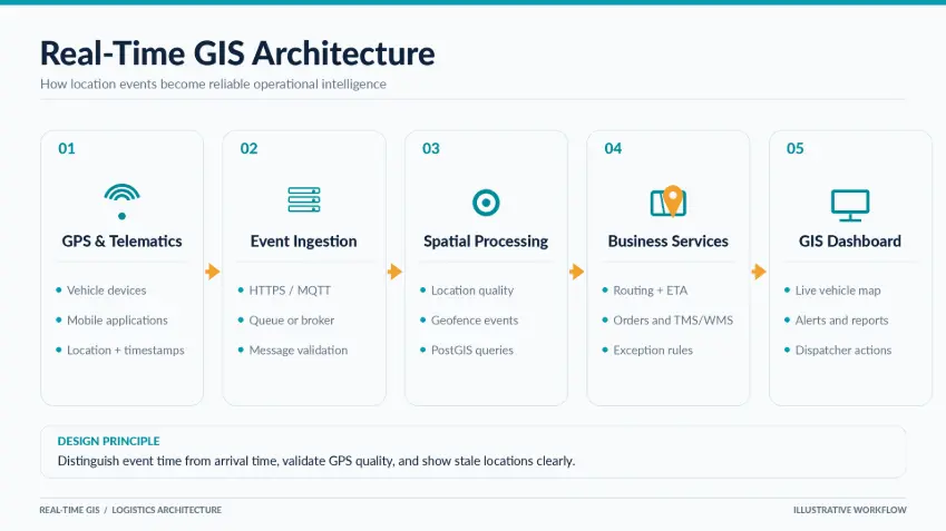
A reliable system typically follows six stages.
1. Collect Location and Operational Data
Location data may come from GPS-enabled fleet devices, mobile applications, telematics systems, or other authorized sources.
For each position update, the system may receive:
- Vehicle identifier
- Latitude and longitude
- Device timestamp
- Reported speed and heading
- Location accuracy or quality indicators
- Device status
Additional operational information may come from a TMS, WMS, order management system, or driver application.
A vehicle position without an associated order or delivery assignment has limited operational meaning.
2. Transmit Events to the Backend
Devices send location updates through mobile or wireless networks.
Depending on the implementation, data transmission may use HTTPS, MQTT, or other suitable communication protocols.
A logistics system should not assume every update arrives immediately or in the correct order.
For example, a truck traveling through an area with poor connectivity may store several position updates and transmit them later.
The backend must distinguish the time an event occurred from the time it was received.
3. Validate and Process Incoming Data
Before location updates influence business decisions, the system should check their quality.
Validation may include:
- Rejecting malformed coordinates
- Confirming device identity
- Identifying duplicate events
- Handling out-of-order timestamps
- Flagging implausible movement
- Detecting stale vehicle positions
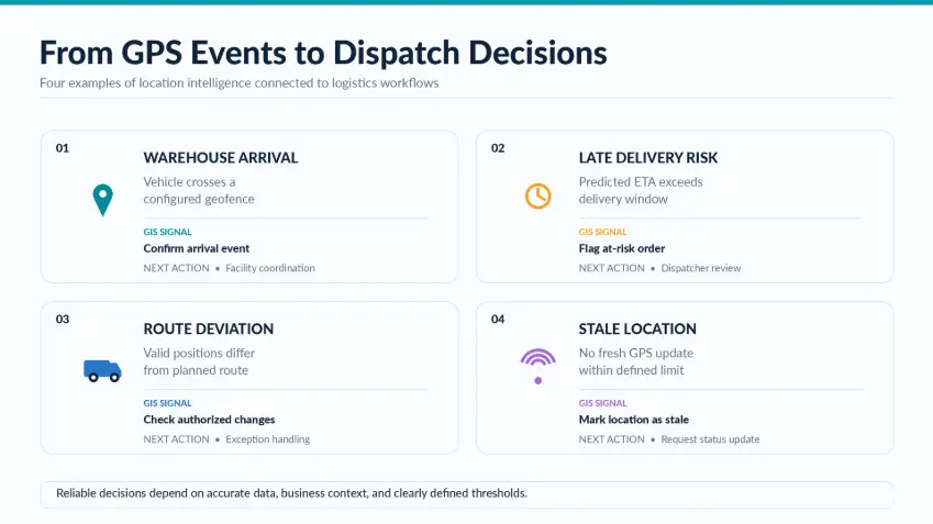
A dashboard should not show a vehicle as confidently live if its most recent location report is substantially delayed.
Displaying the age of an observation is often more useful than displaying a precise-looking but outdated marker.
4. Store and Analyze Geographic Information
A spatial database such as PostgreSQL with PostGIS can store vehicle locations, delivery zones, warehouse positions, and other geographic information.
Spatial queries help applications answer operational questions.
For example:
- Which vehicles are within a specified distance of a depot?
- Which deliveries are assigned to a particular service area?
- Has a vehicle entered a configured geographic zone?
- Which assets are closest to a reported incident?
This is an important distinction: the application does not need to rely solely on what a dispatcher can see on a map.
It can perform geographic calculations in the backend.
5. Connect Spatial Events to Business Logic
Location intelligence becomes more valuable when events have defined operational meaning.
For example:
Event: Vehicle enters warehouse boundary.
Business context: A scheduled pickup is assigned to that warehouse.
Possible workflow: Record the arrival event and update the associated pickup workflow, subject to verification rules.
Another example:
Event: Traffic-aware ETA exceeds a delivery deadline.
Business context: The delivery has a time-sensitive service commitment.
Possible workflow: Flag a late-delivery risk for dispatcher review.
These workflows turn geographic events into information that operations teams can act on.
6. Visualize and Communicate Results
A real-time GIS dashboard presents relevant information through interactive maps and operational views.
Possible interface elements include:
- Latest reported vehicle locations
- Vehicle and shipment details
- Planned and actual route information
- Delivery zones
- Warehouse geofences
- ETA warnings
- Unassigned or delayed deliveries
- Historical event timelines
The dashboard should communicate uncertainty clearly.
For instance, a vehicle last seen 15 minutes ago should not be visually represented in exactly the same way as one reporting fresh location data.
Practical Applications of Real-Time GIS in Logistics
1. Live Fleet Visibility with Operational Context
A live map can show vehicles across a service area.
However, the value increases when the system also displays relevant logistics information.
For example, selecting a vehicle might reveal:
- Current assignment
- Next scheduled stop
- Latest location update time
- Delivery status
- Estimated arrival
- Operational alerts
Dispatchers can prioritize vehicles that require attention rather than inspecting every map marker individually.
Business value: More informed operational monitoring and fewer manual checks across disconnected systems.
2. Geographic Arrival and Departure Detection
Warehouses, distribution centers, and customer sites can be represented as geographic boundaries.
The system can evaluate location updates against these boundaries to identify potential arrival and departure events.
This is commonly called geofencing.
A geofence may be represented as a circle, polygon, or other supported spatial shape.
For example, when a vehicle enters a distribution center's configured boundary, the application could generate an arrival event.
That event may support warehouse coordination or transport status updates.
However, geofencing requires careful design.
GPS uncertainty can cause a vehicle near the edge of a boundary to appear alternately inside and outside it.
Practical systems may use multiple observations, dwell-time rules, or entry/exit thresholds to reduce misleading events.
Business value: More structured visibility into facility visits and transport milestones.
3. Delivery ETA Monitoring
Estimated time of arrival (ETA) is one of the most useful outputs of a logistics application.
A useful ETA depends on more than the distance between two points.
Depending on available services and data, an application may consider:
- Remaining route distance
- Road network conditions
- Traffic information
- Vehicle position
- Planned stops
- Service time at previous destinations
- Operational restrictions
A route calculation service may provide an estimated travel duration.
The logistics application can combine that duration with its own operational information to estimate the expected delivery time.
For example, a route service may estimate 25 minutes of driving, but the shipment may also require a planned loading stop.
Ignoring that operational stop would create an overly optimistic ETA.
Business value: Earlier identification of potentially late deliveries and better information for dispatchers and customers.
4. Route Deviation and Exception Monitoring
A vehicle's reported route may differ from the planned route.
Sometimes this is expected.
Drivers may encounter road closures, temporary restrictions, congestion, or changes requested by dispatch.
A real-time GIS system can compare observations with the planned route and flag meaningful differences.
A useful implementation should distinguish between:
- Small GPS inaccuracies
- Authorized route changes
- Significant route deviations
- Delayed or missing telemetry
- Operationally relevant exceptions
Generating an alert for every minor deviation creates noise.
A better approach is to establish thresholds and connect alerts to the associated transport workflow.
Business value: More focused exception management rather than excessive map monitoring.
5. Geographic Performance Analysis
Once location observations are stored with appropriate permissions and retention controls, businesses can analyze patterns over time.
Possible questions include:
- Which delivery zones experience recurring delays?
- Where do vehicles spend significant amounts of time waiting?
- Which warehouse visits regularly exceed planned durations?
- Which routes frequently require operational adjustments?
- Which service areas generate the most exceptions?
These insights may support route planning, zone design, capacity planning, and service improvement.
The results should be interpreted alongside operational context. A long stop is not necessarily inefficient; it may reflect a required loading activity or customer-service task.
Business value: Evidence-based improvements to logistics processes and geographic coverage.
Real-Time GIS Architecture for Logistics
A practical architecture usually separates data collection, event processing, spatial analysis, and user-facing applications.
Example Technology Stack
| System component | Possible technologies |
|---|---|
| Device communication | MQTT, HTTPS |
| Event ingestion | API gateway, message broker |
| Event processing | Node.js, Java, .NET, Python |
| Spatial database | PostgreSQL + PostGIS |
| Web map | Mapbox, Google Maps, Leaflet, OpenLayers |
| Routing | Commercial or self-hosted routing services |
| Live frontend updates | WebSockets, server-sent events |
| Enterprise integrations | REST APIs, event-driven services |
| Infrastructure | Cloud, private cloud, or hybrid deployment |
These are architectural options, not a requirement to use every component.
Technical Challenges That Matter in Production
Data Freshness and Network Interruptions
A vehicle location may be several minutes old due to coverage gaps or device issues.
Systems should expose timestamps and freshness states rather than implying uninterrupted tracking.
GPS Accuracy and Map Matching
Positioning errors can place a vehicle on the wrong road or outside a nearby facility boundary.
Map matching can help associate observations with plausible road segments, but the result should not be treated as guaranteed ground truth.
Event Ordering
Delayed messages can arrive after newer observations.
Without event-time handling, the system may incorrectly move a vehicle backward on the map or overwrite a more recent position.
Scaling Location Updates
A system receiving frequent updates from many devices may process a substantial volume of events.
Architecture decisions should consider ingestion throughput, storage growth, map rendering, and how often clients genuinely need updates.
Routing Service Costs
Route and travel-time APIs may incur usage-based charges.
Not every vehicle needs its ETA recalculated after every GPS observation.
Event-driven recalculation, appropriate update intervals, and usage monitoring can help control cost.
Privacy and Access Control
Vehicle location data can reveal driver activity and movement patterns.
Organizations should apply appropriate access restrictions, retention policies, security controls, and employee or contractor notices where required.
Integration Complexity
TMS and WMS systems may have different identifiers, status models, and update schedules.
A stable integration design should define the source of truth for each data field and how conflicting updates are resolved.
How to Measure the Value of a Real-Time GIS System
Real-time GIS should be evaluated against operational outcomes.
Rather than measuring success by the number of map features, businesses can establish specific metrics.
| KPI | What it measures |
|---|---|
| Location data freshness | How recently vehicles reported valid positions |
| ETA prediction error | Difference between predicted and actual arrival times |
| Geofence event precision | Reliability of detected arrival/departure events |
| Exception detection delay | Time between a relevant event and its identification |
| Dispatcher response time | Time taken to review or act on flagged exceptions |
| Manual status-check volume | Frequency of calls or messages used to verify locations |
| API and infrastructure cost | Operating cost of geographic services and data processing |
These metrics should be established before implementation.
For example, a pilot can compare how dispatchers handle delayed deliveries before and after introducing a location-aware exception dashboard.
The objective is to measure whether the system improves the workflow, not simply whether the software is technically functional.
How to Implement Real-Time GIS in Logistics
Step 1: Choose a High-Value Operational Scenario
Start with a specific problem, such as monitoring at-risk deliveries or tracking warehouse arrival events.
Avoid beginning with a long feature list.
Step 2: Audit Data Sources
Review GPS availability, update intervals, location quality, operational identifiers, and current logistics software.
Identify data gaps before designing dashboards.
Step 3: Define Event and Business Rules
Agree on what qualifies as an arrival, delay, route deviation, or stale device report.
These definitions should involve operations teams, not just software developers.
Step 4: Build the Minimum Viable Data Pipeline
Develop a workflow that can securely receive, validate, store, and display location events.
Use realistic device and network conditions for testing.
Step 5: Add Spatial Processing
Introduce geofencing, proximity queries, route-related calculations, or other geographic capabilities relevant to the use case.
Step 6: Integrate Operational Systems
Connect geographic events to shipments, vehicles, drivers, orders, and transport workflows.
Step 7: Test Exception Scenarios
Validate behavior during missing signals, inaccurate coordinates, delayed messages, duplicate events, and unexpected route changes.
Step 8: Measure, Improve, and Scale
Compare pilot results against defined operational KPIs.
Expand functionality only when the value and reliability of the initial workflow have been demonstrated.
Real-Time GIS vs. Traditional Logistics Software
The two are not competing categories.
Traditional logistics software generally coordinates processes such as orders, inventory, shipments, transportation, and operational records.
Real-time GIS introduces geographic context, spatial processing, and location-aware event handling.
A business may already use a capable logistics management system but still need additional functionality to connect live movement data with dispatch workflows.
Conversely, a standalone GIS dashboard without proper logistics integration may provide attractive maps but limited operational value.
The strongest architecture is often one where geographic capabilities support existing logistics processes rather than replace them.
Frequently Asked Questions
What is real-time GIS in logistics?
Real-time GIS in logistics is a system that combines frequently updated location information with geographic analysis and business data to support transportation monitoring and operational decisions.
How is real-time GIS different from GPS tracking?
GPS tracking supplies geographic position information. GIS can combine those positions with maps, service areas, routes, spatial relationships, and operational data.
Can real-time GIS improve delivery ETAs?
It can support more informed ETA calculations when current vehicle positions are combined with routing data, traffic information, and operational constraints. ETA accuracy depends on the quality and availability of those inputs.
Does real-time GIS require continuous GPS updates?
No. The necessary update frequency depends on the operational use case. Some workflows need frequent position updates; others can rely on periodic observations or specific events.
What is geofencing in logistics?
Geofencing is the process of evaluating location observations against predefined geographic boundaries, such as warehouse zones or customer sites, to detect relevant entry, exit, or presence events.
Which database is suitable for logistics GIS?
PostgreSQL with PostGIS is one option for storing geographic information and performing spatial queries. Other choices may be appropriate depending on architecture and scale.
Can GIS integrate with a transportation management system?
Yes. GIS services can exchange relevant data with a TMS through APIs, event-driven integrations, or other supported interfaces.
Is Google Maps required for real-time logistics GIS?
No. Applications may use Google Maps Platform, Mapbox, Leaflet, OpenLayers, or other compatible technologies. The choice depends on mapping, routing, licensing, and data requirements.
How much does a real-time GIS platform cost?
Cost depends on the number of devices, update frequency, geographic services, data storage, integrations, security requirements, and development scope. A technical discovery phase is recommended before estimating implementation and operating costs.
Explore Real-Time GIS Development with BHSoft
Developing a real-time geospatial application requires more than a mapping interface.
It involves location-data integration, backend engineering, spatial processing, interactive visualization, secure infrastructure, and enterprise system connectivity.
At Bac Ha Software (BHSoft), we work across custom software development and GIS-related technologies to help organizations explore solutions aligned with practical business needs.
Whether you are considering a live dispatch dashboard, geofencing functionality, or GIS integration with an existing logistics platform, our team can discuss the technical requirements and implementation approach.
Looking to turn logistics location data into better operational decisions?
Talk to our team to explore your real-time GIS application requirements.