How to Build a Map-Based Application: Features, Architecture, Technology Stack, and Development Costs
15 minutes read
November 10, 2026
Why Map-Based Applications Are Becoming Essential to Digital Business
Maps are no longer just tools for finding directions.
Today, businesses use location-based applications to manage deliveries, locate services, track field operations, visualize assets, explore properties, and provide personalized customer experiences.
Consider a logistics company coordinating hundreds of daily deliveries.
An interactive map can show where vehicles are located. However, a complete logistics application may also need route planning, delivery statuses, driver assignments, customer notifications, and operational reporting.
Similarly, a property search platform needs more than location markers. Users may want to filter properties by area, explore nearby facilities, and understand geographic characteristics.
These examples demonstrate an important distinction:
A successful map-based application is not simply a map embedded in software. It is a digital product that uses geographic information to solve a specific problem.
Building such an application requires thoughtful decisions about user experience, mapping technology, geographic data, backend infrastructure, and integration.
This guide explains the essential components of map app development, the technologies available, and the steps businesses should follow to create a reliable location-based product.
What Is a Map-Based Application?
A map-based application is a web or mobile software application that uses geographic data to display locations, enable spatial interactions, or provide services based on location.
A map application typically combines an interactive geographic interface with business information and software functionality.
Examples include:
- Delivery and fleet tracking applications
- Store and service locators
- Property search platforms
- Field service management applications
- Travel and tourism applications
- Ride-hailing and mobility services
- Infrastructure and asset monitoring tools
- Location-based workforce applications
Depending on the purpose, applications may use static geographic information or frequently updated location data.
Some require only basic maps and markers. Others include complex geographic analysis, navigation, real-time messaging, or offline operation.
Map Applications vs. GIS Applications: What's the Difference?
Map applications and Geographic Information Systems (GIS) share many underlying technologies.
However, they often serve different primary purposes.
A map application usually emphasizes location-based interactions and workflows.
A GIS application commonly focuses on geographic data management, spatial analysis, and more complex geographic datasets.
| Capability | Map-Based Application | GIS Application |
|---|---|---|
| Interactive maps | Core feature | Core feature |
| Location search | Common | Common |
| GPS tracking | Application-dependent | Can be integrated |
| Route planning | Common in mobility applications | Can be integrated |
| Multiple geographic layers | Depends on requirements | Often central |
| Spatial analytics | Usually targeted | May be extensive |
| Geographic data editing | Optional | Frequently required |
| Enterprise workflows | Application-specific | Often data and asset focused |
The boundaries are flexible.
For example, a logistics platform may begin as a map-based application and later incorporate advanced GIS analysis. What matters is designing the system around the intended users and business objectives.
Essential Features of a Modern Map-Based Application
1. Interactive Map Visualization
An interactive map is usually the primary interface.
Users should be able to explore locations through zooming, panning, searching, and selecting geographic objects.
Depending on the project, the application may include:
- Custom map styles
- Location markers and popups
- Marker clustering
- Routes and geographic boundaries
- Map layer controls
- Heatmaps
- Custom overlays
- 2D or 3D visualization
Map design should support the user's task rather than display unnecessary geographic detail.
For example, a delivery tracking application may prioritize routes, stops, and vehicle positions, while a real estate application emphasizes properties and nearby amenities.
2. GPS and Device Location
Many applications use device location services to determine an approximate user position.
Smartphones commonly combine GPS or other satellite positioning signals with Wi-Fi and cellular information.
The accuracy of location estimates depends on device capabilities, environmental conditions, permissions, and available signals.
GPS functionality can support:
- Nearby service discovery
- Field employee check-ins
- Delivery location updates
- Asset positioning
- Route recording
- Location-based notifications
Applications should clearly explain why location access is needed and avoid collecting information beyond the intended purpose.
3. Geocoding and Reverse Geocoding
Geocoding converts an address into geographic coordinates.
Reverse geocoding converts a geographic position into a human-readable address or place description.
For instance, a customer might enter a delivery address into an application.
A geocoding service can provide coordinates that the application uses to display the location on a map.
Reverse geocoding may help field personnel identify an approximate address based on their reported position.
Geocoding accuracy can vary, particularly when addresses are incomplete or ambiguous.
4. Routing and Navigation
Routing systems calculate paths between geographic locations.
Depending on the provider and configuration, they may consider road networks, travel modes, traffic conditions, restrictions, and multiple stops.
Common applications include:
- Delivery route planning
- Field service scheduling
- Travel planning
- Transportation services
- Customer navigation
It is important to distinguish between routing and turn-by-turn navigation.
Routing generates a path or directions, while a navigation experience may additionally require live positioning, progress monitoring, rerouting, and instruction presentation.
5. Real-Time Location Tracking
Some businesses require timely updates about moving vehicles, personnel, or assets.
A real-time tracking system can collect authorized location updates and transmit them to backend services.
These updates can then appear on a live map.
However, real-time does not always mean continuous or instantaneous.
Update frequency should be designed around operational requirements, connectivity, battery consumption, and infrastructure costs.
6. Geofencing
Geofencing uses virtual geographic boundaries to support location-based events.
For example, a business may define an area around a warehouse.
When an authorized device enters or exits the area, the application can generate an event.
Potential uses include arrival notifications, field service check-ins, delivery milestones, and equipment monitoring.
Accuracy limitations and mobile operating-system restrictions must be considered.
7. Offline Mapping
Some applications operate in environments with unreliable connectivity.
Field service, inspection, and remote infrastructure applications may require offline functionality.
Possible capabilities include locally available map data, stored assignments, offline event capture, and delayed synchronization.
Offline map availability depends on the selected provider, technical architecture, and applicable licensing terms.
How Does a Map-Based Application Work?
A typical map application consists of several connected layers.
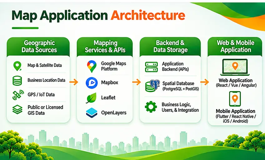
Layer 1: Geographic Data Sources
The application receives geographic information from relevant sources.
Examples include:
- Maps and road networks
- GPS and mobile device location services
- Business-owned geographic records
- Places and address databases
- IoT tracking devices
- Public or licensed geographic datasets
Data quality and licensing should be evaluated before integration.
Layer 2: Mapping APIs and SDKs
Mapping technologies provide the tools needed to display geographic information and support location-based interactions.
For example, Google Maps Platform provides map, routing, places, and geocoding services.
Mapbox provides customizable mapping technologies and location services.
Open-source libraries such as Leaflet and OpenLayers allow developers to render interactive maps using suitable geographic data sources.
Layer 3: Backend Services
The backend manages the application's business logic.
Typical responsibilities include authentication, user management, operational rules, location events, notifications, reporting, and integrations.
Backend services may also communicate with external mapping APIs.
Layer 4: Database and Spatial Storage
Applications need to store user information, locations, assets, events, and business records.
PostgreSQL is a common database choice.
The PostGIS extension adds spatial data types and geographic functions.
For example, a service application may need to identify technicians within a specified distance of a customer location.
A spatial database can support this type of query.
Layer 5: Web or Mobile Frontend
The frontend connects the user to the underlying services.
Web applications commonly use React, Vue, or Angular.
Mobile applications may be developed using Swift, Kotlin, Flutter, or React Native.
The best frontend technology depends on the expected devices, user workflows, team expertise, and native capabilities required.
Which Technology Stack Is Best for Map App Development?
There is no universal technology stack for every mapping application.
| Component | Technology Options | Typical Purpose |
|---|---|---|
| Web frontend | React, Vue, Angular | Browser-based interfaces |
| Mobile application | Flutter, React Native, Swift, Kotlin | Mobile user experiences |
| Map visualization | Google Maps, Mapbox, Leaflet, OpenLayers | Interactive map display |
| Backend | Node.js, .NET, Python, Java | APIs and business logic |
| Spatial database | PostgreSQL + PostGIS | Geographic queries and storage |
| Real-time communication | WebSockets, MQTT, HTTPS | Location update delivery |
| Identity and access | OAuth 2.0, OpenID Connect | Authentication |
| Infrastructure | Cloud, private cloud, hybrid | Deployment and scaling |
Google Maps vs. Mapbox vs. Leaflet vs. OpenLayers
Choosing a mapping platform should be based on project requirements.
- Google Maps Platform is relevant for applications that need integrated maps, place discovery, geocoding, and routing.
- Mapbox is an option for applications requiring customizable map styles and interactive vector-map experiences.
- Leaflet is an open-source JavaScript library suitable for lightweight interactive web maps.
- OpenLayers is an open-source library well suited to applications involving more advanced geographic layers, data formats, and GIS-oriented functionality.
It is important to understand that Leaflet and OpenLayers do not automatically provide the same commercial geographic datasets or location services as Google Maps Platform or Mapbox.
Businesses may need to integrate separate tile providers, routing engines, or geocoding services.
Five Common Business Applications of Mapping Technology
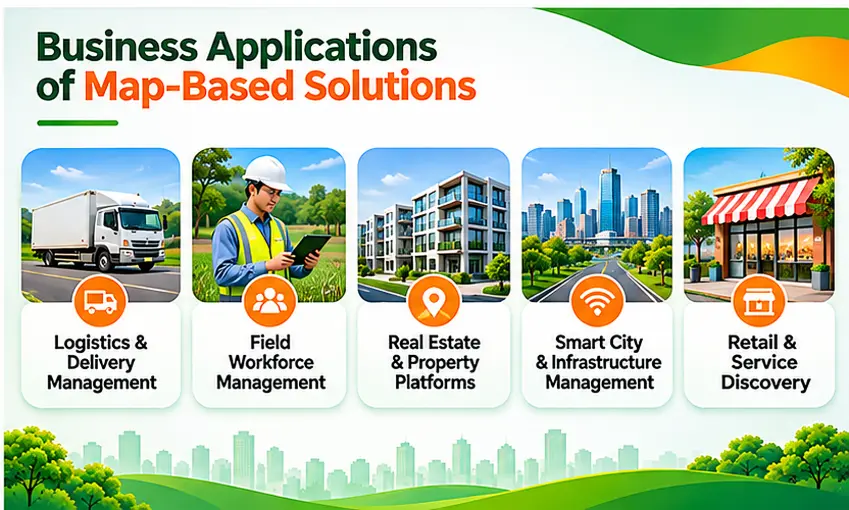
1. Logistics and Delivery Management
Logistics platforms can combine vehicle locations, delivery destinations, routes, and operational information.
For example, dispatch teams may use a live map to review the latest reported vehicle positions and identify deliveries requiring attention.
Business value: Better operational visibility and more informed dispatch coordination.
2. Field Workforce Management
Sales representatives, service technicians, and inspection teams work across multiple locations.
Map applications can support location-aware attendance, assigned visits, service territories, and authorized field tracking.
Business value: More structured operational records and improved coordination between office and field teams.
3. Real Estate and Property Applications
Property platforms rely on geographic information to help users explore available locations.
Features may include map-based property search, geographic filters, nearby services, and travel accessibility.
Business value: More useful property discovery and better location-based information for customers.
4. Smart City and Infrastructure Management
Cities and infrastructure operators manage assets across geographically distributed environments.
Map applications can connect infrastructure records with GIS visualizations and selected IoT information.
Business value: Better location-based monitoring and infrastructure management.
5. Retail and Service Discovery
Retailers can use maps to help customers find stores, service centers, or nearby facilities.
Location-based search can improve access to relevant business information.
Business value: Easier location discovery and a more convenient customer experience.
How to Build a Map-Based Application: Step by Step
Step 1: Identify the Business Problem
Begin with a specific use case.
For example, a field service organization may need to help managers identify available technicians near assigned jobs.
That requirement should drive the design.
Step 2: Define the Core Features
Separate essential functionality from optional enhancements.
For an initial field service application, the MVP might include map visualization, technician locations, job assignments, and status updates.
Advanced route optimization or predictive analytics can be considered later.
Step 3: Evaluate Geographic Data
Identify where the geographic information will come from.
Review data accuracy, geographic coverage, licensing, update frequency, and storage rights.
Step 4: Select Mapping APIs and Technologies
Compare available providers and libraries according to feature requirements, customization, performance, licensing, and operating costs.
Step 5: Design the Application Architecture
Define how mobile or web interfaces, mapping services, databases, and backend APIs will communicate.
Establish the security and privacy approach early.
Step 6: Develop an MVP
Build a limited application that demonstrates the primary workflow.
An MVP helps evaluate real requirements before investing in extensive additional features.
Step 7: Test in Real Geographic Conditions
Test location accuracy, navigation behavior, performance, permissions, network interruptions, and unusual geographic scenarios.
Step 8: Deploy and Monitor
Monitor application performance, API consumption, system reliability, and user feedback.
Expand the product based on validated operational needs.
How Much Does Map App Development Cost?
There is no fixed cost for building a map-based application.
A simple business location finder requires significantly less engineering than a real-time logistics platform with route optimization, user management, and enterprise integration.
Main Cost Factors
Application complexity: The number of user roles, workflows, and features affects development effort.
Mapping APIs: Maps, routing, geocoding, and place search may use different billing models.
Backend infrastructure: Servers, databases, monitoring systems, and real-time messaging introduce ongoing costs.
Data licensing: Geographic imagery, places databases, or specialized datasets may require paid access.
Integration: Connecting an application to existing ERP, CRM, or operational platforms can increase implementation effort.
Security and compliance: Location data, authentication, and access-control requirements influence system design.
Maintenance: Applications require ongoing updates, performance monitoring, and support.
Mapping API Cost Considerations
Google Maps Platform uses service-specific billing units for different map and location capabilities.
Mapbox GL JS web applications are billed according to map loads, while other Mapbox products and APIs have separate pricing models.
Developers should estimate actual usage rather than calculate costs based on user count alone.
An application with a small number of users making frequent routing or location-search requests may have a different cost profile from an application serving many users with relatively simple static maps.
How to Estimate Your Map App Budget
A practical estimate should begin with:
- Expected users and geographic coverage
- Core features and workflows
- Required external APIs
- Estimated map loads and location requests
- Backend and database requirements
- Security and integration needs
- Ongoing infrastructure and maintenance
A scoped technical discovery phase can provide a more useful estimate than an arbitrary fixed development price.
Common Challenges in Map App Development
Location Accuracy
GPS estimates can be affected by signal obstruction, buildings, tunnels, and device limitations.
Applications should not assume every coordinate is exact.
Mapping Performance
Large numbers of markers or geographic features can affect rendering performance.
Possible solutions include clustering, filtering, vector tiles, and server-side aggregation.
Usage-Based Costs
Frequent API requests or inefficient map initialization can increase operating expenses.
Monitoring usage and optimizing application behavior are important.
Offline Requirements
Offline functionality needs explicit design for geographic data storage and synchronization.
Provider licensing may restrict how map content can be downloaded or retained.
Data Privacy and Security
Location information can be sensitive, especially when associated with employees or individual users.
Organizations should define appropriate collection purposes, permissions, data-retention policies, and security controls.
Third-Party Dependencies
External API changes, pricing updates, licensing restrictions, and service availability may affect long-term operations.
Architectures should avoid unnecessary provider coupling where practical.
How AI and GIS Can Extend Map Applications
A map-based application can evolve beyond basic location visualization.
AI-Powered Location Intelligence
AI can support selected tasks such as geographic demand forecasting, location recommendations, or spatial pattern analysis.
IoT and Live Location Data
Connected devices can provide geographic and operational observations that appear within an application's map interface.
Advanced GIS Integration
Spatial databases and GIS services can support complex queries, geographic data editing, and multi-layer analysis.
Digital Twin Applications
Mapping systems may become part of broader digital representations of physical infrastructure.
Not every product needs these advanced capabilities. They should be introduced when the business problem justifies the investment.
Frequently Asked Questions About Map App Development
What is map app development?
Map app development is the process of building web or mobile applications that use geographic information to display locations, provide location-based services, or support geographic business workflows.
What programming languages are used for map applications?
Common options include JavaScript or TypeScript for web development, Swift and Kotlin for native mobile applications, Dart for Flutter, and languages such as Python, C#, or Java for backend services.
Can I build a map application without Google Maps?
Yes. Developers can use alternatives such as Mapbox, Leaflet, OpenLayers, and suitable map-data and location-service providers.
How much does it cost to develop a map app?
Costs depend on functionality, data sources, mapping services, backend infrastructure, integrations, security, and maintenance requirements.
Does every map application need GPS?
No. Property platforms, infrastructure dashboards, and geographic data viewers can provide useful functionality without accessing the user's current location.
Can a map application work offline?
Yes, if the architecture and selected mapping technologies support locally available map data and offline workflows.
Can AI be integrated into a map application?
Yes. AI can support location recommendations, predictive analytics, image analysis, and other features when appropriate data and validation are available.
What is the difference between a map application and GIS software?
Map applications usually emphasize user-facing location services and workflows. GIS software commonly includes broader spatial data management and analysis capabilities, although the two categories can overlap.
Conclusion: Build Location-Based Applications Around Real Business Needs
Map application development involves much more than placing markers on a digital map.
Successful products connect geographic data, mapping technologies, backend services, and practical business processes.
Whether the goal is improving logistics visibility, supporting mobile workers, helping customers discover nearby services, or managing infrastructure, the most important starting point is a clearly defined use case.
The right architecture should support performance, security, usability, and manageable long-term costs.
Organizations that begin with a focused MVP and validate their approach can build stronger foundations for future functionality.
Explore Map Application Development with BHSoft
Building a reliable location-based application requires expertise across frontend development, mobile technology, backend systems, geographic information, and application integration.
At BHSoft, we understand how these technologies can be combined to address business requirements.
Whether you are developing a GPS-enabled mobile application, an interactive mapping platform, or a GIS-integrated enterprise solution, our team can discuss the technical approach and development considerations.
Planning to build a custom map application?
Talk to our team to discuss your project requirements and explore a scalable software architecture.