GeoAI in 2026: How Artificial Intelligence Is Transforming GIS and Location Intelligence
15 minutes read
November 03, 2026
Why GeoAI Matters in 2026
Every business operates somewhere.
Retailers choose store locations. Logistics providers manage delivery networks. Utility companies maintain geographically distributed infrastructure. Governments monitor urban development and environmental conditions.
Behind these operations lies an enormous amount of geographic information.
Satellite imagery, GPS coordinates, drone data, IoT sensors, and Geographic Information Systems (GIS) help organizations understand the physical world.
However, collecting and visualizing location data is only part of the challenge.
The real opportunity is turning geospatial information into intelligent, actionable insights.
This is where Geospatial Artificial Intelligence, commonly called GeoAI, becomes increasingly valuable.
By combining artificial intelligence with GIS and spatial analytics, GeoAI can help organizations recognize geographic patterns, identify changes, automate data processing, and support predictive decision-making.
In 2026, the growing focus on AI-ready geospatial data, Earth observation models, and interoperable platforms is creating new opportunities for businesses to develop intelligent location-based solutions.
So, what exactly is GeoAI, how does it work, and where can it create business value?
To effectively present complex spatial predictive models generated by artificial intelligence, integrating your system with 3D mapping using CesiumJS provides dynamic, real-time visualization for urban planners and decision-makers.
What Is GeoAI?
GeoAI (Geospatial Artificial Intelligence) is the application of artificial intelligence and machine learning techniques to geographic and location-based data to analyze spatial relationships, identify patterns, and support predictions or decisions.
GeoAI brings together several technologies:
- Geographic Information Systems (GIS): Tools for managing, visualizing, querying, and analyzing geographic information.
- Artificial Intelligence (AI): Computational techniques that recognize patterns and support automated predictions or decisions.
- Machine Learning (ML): Algorithms that learn relationships from data.
- Remote Sensing: Methods for collecting information about Earth's surface using satellites, aircraft, or drones.
- Spatial Analytics: Techniques for investigating geographic patterns, relationships, and distributions.
Traditional GIS systems allow users to view geographic information, perform spatial queries, and create analytical maps.
GeoAI adds capabilities such as automated feature detection, image classification, spatial forecasting, and anomaly identification.
A Simple Example of GeoAI
Imagine an urban planning department analyzing satellite images to understand how a city has changed over several years.
A conventional GIS workflow might involve manually identifying new buildings, roads, and land-use changes.
A GeoAI workflow could use trained computer vision models to identify building footprints and detect selected changes between images.
The resulting information can then be reviewed, validated, and displayed in a GIS application.
This can reduce manual processing for certain tasks while helping planners investigate larger geographic areas.
The AI does not replace the need for accurate data or expert interpretation. It helps make selected analytical workflows more efficient.
When designing the user interface for spatial machine learning models, development teams should carefully analyze feature sets and performance by comparing Mapbox, OpenLayers, and Leaflet to ensure optimal frontend rendering.
How Does GeoAI Work?
A typical GeoAI application follows five stages.
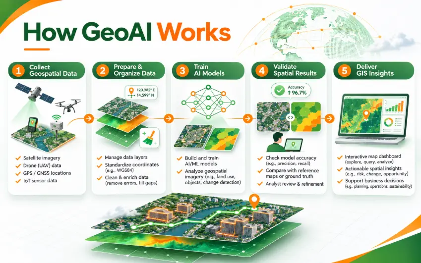
1. Geospatial Data Collection
The first step is gathering geographic information from relevant sources.
These may include:
- Satellite and aerial imagery
- Drone observations
- GPS and GNSS measurements
- IoT sensor data
- Geographic databases
- Road and transportation networks
- Environmental and terrain datasets
- Business and demographic information with geographic references
The choice of data depends on the intended application.
For example, an agricultural monitoring solution may require vegetation imagery and weather information, while a retail location intelligence platform may use demographic data, business locations, and transportation networks.
2. Data Preparation and Spatial Processing
Geospatial information often comes from different systems, formats, resolutions, and coordinate reference systems.
Before applying AI, developers may need to:
- Clean missing or inconsistent records.
- Standardize geographic coordinates.
- Align imagery from different sources.
- Prepare raster and vector datasets.
- Create geographic features for model training.
- Validate data quality and provenance.
For GeoAI projects, spatial data preparation is especially important.
An otherwise capable AI model can produce unreliable outputs if geographic information is misaligned or its source data is unrepresentative.
3. AI Model Development
Once the data is prepared, engineers select AI techniques appropriate to the business problem.
Examples include:
- Computer vision: Detecting buildings, vehicles, land-cover categories, or infrastructure features in imagery.
- Supervised machine learning: Learning relationships between geographic characteristics and labeled outcomes.
- Time-series analysis: Identifying temporal patterns in environmental or operational data.
- Deep learning: Processing complex imagery and spatial datasets.
- Geospatial foundation models: Using models pretrained on broad Earth observation datasets and adapting them to specific analytical tasks.
Model selection should consider data availability, computational requirements, explainability, and operational risk.
4. Spatial Validation and Analysis
AI-generated results must be evaluated before operational use.
Geospatial data introduces a special challenge: locations near one another often share similar characteristics.
If training and test datasets contain highly related neighboring observations, the reported model accuracy may be misleading.
For this reason, GeoAI projects may require geographically separated validation, independent reference datasets, and expert review.
The objective is to understand how well a model works in the locations and conditions where it will actually be used.
5. GIS Integration and Business Applications
Validated results can be delivered through web applications, GIS dashboards, spatial databases, or business APIs.
For example, an infrastructure monitoring platform could display potential asset anomalies on an interactive map.
Operators could inspect affected locations, review supporting information, and prioritize field inspections.
This integration turns AI-generated outputs into information that can support real operational workflows.
When designing the user interface for spatial machine learning models, development teams should carefully analyze feature sets and performance by comparing Mapbox, OpenLayers, and Leaflet to ensure optimal frontend rendering.
GeoAI vs. Traditional GIS: What's the Difference?
Traditional GIS and GeoAI are complementary technologies.
| Capability | Traditional GIS | GeoAI |
|---|---|---|
| Map visualization | Core capability | Typically integrated with GIS |
| Spatial queries | Spatial functions and defined analytical rules | Can combine spatial queries with AI predictions |
| Geographic feature identification | Manual or rule-based methods | AI-assisted detection and classification |
| Predictive capabilities | Spatial statistics and modeling | Machine learning and advanced predictive models |
| Image analysis | Manual and conventional image processing | Deep learning and computer vision |
| Workflow automation | Scripts and configured processes | AI-assisted automation of selected tasks |
GeoAI does not eliminate the need for GIS.
GIS remains essential for geographic data management, visualization, and spatial analysis. GeoAI extends these foundations with machine learning capabilities.
For many enterprises, the strongest architecture combines traditional GIS services with carefully selected AI components.
Five Real-World GeoAI Applications for Businesses
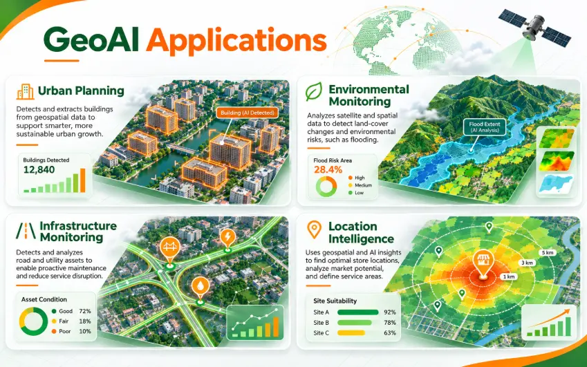
1. Smart City Planning and Urban Development
Cities continuously change.
New buildings appear, transportation networks expand, and land-use patterns evolve.
GeoAI can help urban planners analyze imagery and geographic datasets to understand these changes.
Potential applications include:
- Automated building footprint detection
- Land-use and land-cover classification
- Urban expansion monitoring
- Green space analysis
- Infrastructure planning support
Business value: More scalable geographic analysis, improved change detection, and better access to information for planning decisions.
For Smart City platforms, these outputs can be integrated with GIS dashboards and other urban management systems.
2. Environmental Monitoring and Disaster Risk Analysis
Environmental conditions change across both geography and time.
GeoAI can combine terrain, satellite imagery, environmental observations, and historical records to support environmental analysis.
Potential applications include:
- Flood extent mapping
- Land-cover change detection
- Wildfire-related risk assessment
- Vegetation monitoring
- Environmental anomaly identification
For example, satellite-derived information can help analysts identify potentially flooded areas after major rainfall events.
However, outputs must be validated and interpreted using suitable environmental models and expert knowledge.
Business value: Broader geographic visibility and improved analytical support for monitoring and preparedness.
3. Infrastructure and Asset Monitoring
Organizations managing roads, pipelines, utility networks, and telecommunications infrastructure need accurate information about geographically distributed assets.
GeoAI can support selected inspection and analytical tasks.
Potential applications include:
- Infrastructure feature extraction from imagery
- Change detection near critical assets
- Geographic risk classification
- Maintenance prioritization support
- Automated identification of potential anomalies
For instance, imagery analysis may help identify changes along utility corridors that warrant field inspection.
Business value: More informed maintenance planning and reduced dependence on manually reviewing every geographic observation.
4. Agriculture and Land Management
Agricultural operations depend heavily on geographic and environmental conditions.
GeoAI can analyze crop imagery, terrain information, vegetation indicators, and weather-related data.
Possible applications include:
- Crop classification
- Vegetation health analysis
- Land-use monitoring
- Identification of areas requiring inspection
- Spatial analysis of agricultural conditions
Business value: Better location-specific monitoring and potentially more efficient allocation of inspection and management resources.
5. Business Location Intelligence
Location influences customer accessibility, infrastructure costs, service coverage, and market opportunities.
GeoAI can help organizations analyze geographic patterns that traditional business reporting may not reveal.
Applications include:
- Retail site selection
- Service-area planning
- Geographic demand forecasting
- Property and development analysis
- Delivery network planning
For example, a retailer could combine geographic demand indicators, transportation accessibility, and existing store coverage to evaluate candidate locations.
Business value: Better-informed geographic investment and operational decisions.
AI-generated recommendations should remain one input among commercial, financial, and operational considerations.
Before applying deep learning models to multi-dimensional spatial environments, understanding what 3D mapping is and its practical uses provides essential context for structuring your input training datasets.
What Technologies Are Used to Build GeoAI Applications?
GeoAI solutions typically combine AI frameworks, GIS infrastructure, geographic databases, and web application technologies.
| Technology Layer | Common Technologies | Purpose |
|---|---|---|
| AI and machine learning | Python, PyTorch, TensorFlow, scikit-learn | Model development and inference |
| Geospatial processing | GDAL, Rasterio, GeoPandas | Preparing raster and vector data |
| GIS desktop and services | QGIS, GeoServer | Geographic analysis and data services |
| Spatial database | PostgreSQL with PostGIS | Storing and querying geographic information |
| Mapping frontend | Mapbox, OpenLayers, Leaflet | Interactive geographic visualization |
| Backend services | Python, Node.js, .NET, Java | APIs, application logic, and integration |
| Infrastructure | Cloud, hybrid, or on-premises platforms | Processing, storage, and deployment |
Technology choices depend on application complexity, data volume, security requirements, and expected usage.
For example, a GeoAI system processing large satellite imagery archives requires a different architecture from a business location intelligence dashboard using existing structured geographic datasets.
Emerging GeoAI Trends in 2026
AI-Ready Geospatial Data
One of the important developments in geospatial technology is the push toward data that AI systems can discover, interpret, and reuse more reliably.
In August 2026, the Open Geospatial Consortium published a technical paper outlining building blocks for interoperable, AI-ready geospatial datasets.
The framework emphasizes concepts such as data profiles, discovery, shared terminology, and provenance.
For businesses, this reinforces the importance of well-organized geographic data and interoperable architectures.
Geospatial Foundation Models
Foundation models trained on large Earth observation datasets are creating opportunities to reuse learned representations across different geographic analysis tasks.
Organizations may be able to adapt pretrained models instead of developing every model entirely from scratch.
However, local validation remains necessary because performance can vary across regions, sensors, and environmental conditions.
Natural-Language GIS Interfaces
AI-assisted interfaces may enable users to interact with geographic information using natural-language questions.
For example: Which infrastructure assets are located within the selected flood-risk zone?
An application could interpret the question, construct a suitable spatial query, and present the result on a map.
Such systems require careful controls to prevent inaccurate queries or misleading interpretations.
GeoAI and Digital Twins
Geospatial digital twins combine geographic representations with relevant physical-system information.
GeoAI can contribute analytical layers such as detected infrastructure changes, environmental classifications, or predictive risk indicators.
Together, these capabilities may help organizations build richer digital representations of physical environments.
Challenges of GeoAI Implementation
Despite its potential, GeoAI introduces several challenges:
- Data quality: Geographic datasets may have incomplete coverage, inconsistent coordinates, outdated information, or limited metadata.
- Model generalization: A model trained in one region may not perform equally well elsewhere.
- Computational requirements: Large satellite imagery datasets and advanced deep learning models may require significant infrastructure.
- Interoperability: Different geospatial systems may use incompatible formats, identifiers, and data structures.
- Privacy and governance: Some location information can reveal sensitive operational or personal data.
- Explainability: Organizations need to understand the limitations and uncertainty of AI-generated spatial recommendations.
These challenges should be addressed during solution design rather than after deployment.
How to Implement GeoAI in Your Business
Organizations considering GeoAI should begin with a focused use case and clear business objectives.
Step 1: Identify a Geographic Problem
Choose a challenge involving spatial data that could benefit from machine learning.
Examples include repetitive imagery review, geographic anomaly detection, or location-based forecasting.
Step 2: Assess Available Data
Review geographic coverage, quality, licensing, accuracy, and update frequency.
Step 3: Define Success Metrics
Select measurable indicators such as detection accuracy, processing time, geographic coverage, or operational efficiency.
Step 4: Design the Technical Architecture
Determine how GIS, AI models, databases, APIs, and business applications will interact.
Step 5: Develop a Proof of Concept
Test the approach using a limited but representative dataset.
Step 6: Validate Geographically
Evaluate model performance against independent geographic data and realistic operating conditions.
Step 7: Integrate with Business Workflows
Present useful outputs through GIS maps, dashboards, APIs, or existing enterprise applications.
Step 8: Scale and Monitor
Expand successful deployments while monitoring data quality, model performance, infrastructure costs, and user feedback.
Frequently Asked Questions About GeoAI
What is the difference between GeoAI and GIS?
GIS is used to manage, visualize, and analyze geographic information. GeoAI applies artificial intelligence and machine learning to spatial data to automate analysis, identify patterns, and generate predictions.
What is GeoAI used for?
GeoAI is used for applications such as satellite imagery classification, urban development monitoring, environmental analysis, infrastructure inspection support, and business location intelligence.
Is GeoAI the same as geospatial analytics?
No. Geospatial analytics encompasses many geographic analytical methods. GeoAI specifically uses AI or machine learning techniques within geospatial workflows.
Does GeoAI require satellite imagery?
No. GeoAI can also use GPS coordinates, IoT sensor observations, road networks, terrain information, demographic datasets, and other geographically referenced information.
Can GeoAI integrate with existing GIS platforms?
Yes. GeoAI models can be integrated through APIs, spatial databases, GIS services, and processing pipelines, depending on the existing system architecture.
What are the main challenges of GeoAI development?
Common challenges include geographic data quality, model validation, infrastructure requirements, interoperability, privacy, and integration with business workflows.
How can businesses start using GeoAI?
Businesses should begin with a measurable geographic problem, evaluate their data readiness, and develop a limited proof of concept before committing to a large-scale implementation.
Conclusion: GeoAI Is Making Geographic Information More Actionable
Geospatial technology is evolving beyond maps and traditional spatial analysis.
By combining artificial intelligence with geographic information, GeoAI helps organizations identify patterns, automate selected analytical tasks, and make better-informed location-based decisions.
From Smart City planning to environmental monitoring, infrastructure management, and business location intelligence, GeoAI creates opportunities to extract more value from spatial data.
However, successful adoption requires more than an AI model.
Businesses need reliable geographic datasets, appropriate validation, scalable architecture, and clear operational objectives.
The most effective GeoAI solutions connect advanced analytics with practical workflows and measurable business value.
Explore GeoAI and GIS Development with BHSoft
Building intelligent geospatial applications requires a combination of software engineering, GIS expertise, AI integration, and scalable system architecture.
At BHSoft, we help organizations explore practical approaches to custom software development and intelligent geospatial solutions.
Whether your business is considering AI-powered geographic analytics, a custom GIS platform, or a location-enabled application, our team can discuss the architecture and development requirements.
Ready to turn geographic data into business value?
Talk to our team to discuss your GIS and GeoAI development needs.