Custom GIS Application Development: A Complete Guide
15 minutes read
November 05, 2026
Why Businesses Need More Than Standard Maps
Location plays an important role in business operations.
Logistics companies need to track vehicles and plan delivery networks. Utility providers manage infrastructure distributed across cities and regions. Real estate developers evaluate properties and geographic conditions. Governments need to monitor roads, urban infrastructure, environmental conditions, and public assets.
Yet many organizations still manage location-based information using spreadsheets, static maps, or disconnected software systems.
These approaches can become difficult to maintain as data volumes increase and business requirements become more complex.
For example, imagine an infrastructure operator managing thousands of assets across multiple geographic areas. Knowing where those assets are located is useful.
But the organization may also need to know which assets are overdue for maintenance, which are located in flood-prone areas, and how to coordinate field teams efficiently.
A basic digital map cannot always address these requirements.
Custom GIS application development helps businesses turn geographic information into interactive, analytical, and operational software systems.
Instead of simply displaying locations, a custom GIS platform can connect spatial data with business processes, supporting better decisions and more efficient workflows.
This guide explains what custom GIS development involves, how GIS applications are built, which technologies are commonly used, and what organizations should consider before investing.
What Is Custom GIS Application Development?
Custom GIS application development is the process of designing and building software that collects, stores, manages, analyzes, and visualizes geographic information according to specific business requirements.
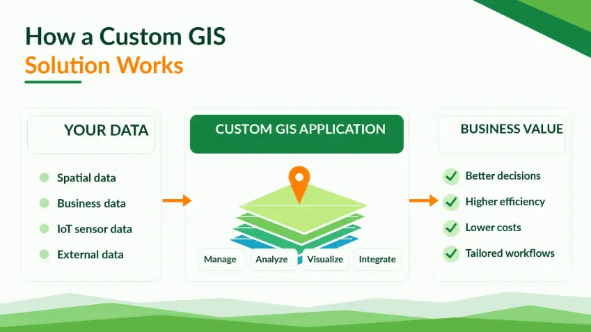
A Geographic Information System (GIS) works with data associated with geographic locations.
This information may represent physical assets, geographic boundaries, transportation networks, environmental conditions, or business locations.
A custom GIS application combines these datasets with functionality tailored to an organization's workflows.
Typical capabilities include:
- Interactive geographic maps
- Spatial data management
- Layer visualization and filtering
- Geographic search and analysis
- Asset tracking and management
- Real-time data integration
- Operational dashboards and reports
- Integration with existing enterprise software
For example, a utility provider could build a GIS application that displays power infrastructure, maintenance records, and geographic service areas.
Authorized employees could select an asset on the map, review its condition, and access associated maintenance information.
The system could also identify assets within a selected geographic boundary or within a defined distance of an incident.
This transforms geographic data into an operational tool rather than a standalone visualization.
Custom GIS vs. Traditional Map Applications: What's the Difference?
Although GIS applications and digital map applications share some technologies, they serve different purposes.
A conventional map application primarily focuses on location display, navigation, or place discovery.
A GIS application can additionally support complex spatial datasets, geographic analysis, and specialized workflows.
| Capability | Basic Map Application | Custom GIS Application |
|---|---|---|
| Interactive map display | Yes | Yes |
| Location search | Common | Common |
| Multiple geographic layers | Limited or application-specific | Often central |
| Spatial queries | Usually limited | Advanced, depending on requirements |
| Geographic data editing | Not always available | Can be supported |
| Asset management | Requires additional functionality | Can be built into workflows |
| Business system integration | Possible | Often a major requirement |
| Spatial analytics | Usually limited | Can support advanced analysis |
| Enterprise permissions | Application-specific | Can be designed around organizational roles |
The distinction is not absolute.
A sophisticated map application can include GIS functionality, while a lightweight GIS application may primarily provide geographic visualization.
What matters is the underlying business problem and required capabilities.
When Should a Business Invest in Custom GIS Software?
Not every organization needs custom-built GIS software. Existing mapping products and GIS platforms may already support many requirements.
However, custom development can become valuable when standard tools cannot adequately support an organization's operational needs.
1. Complex Geographic Data
Businesses may need to work with multiple geographic datasets, such as buildings, road networks, land parcels, utility lines, sensor locations, and environmental boundaries.
A custom platform can provide a unified interface for these datasets.
2. Specialized Business Workflows
An infrastructure company may need inspection workflows linked to geographic assets.
A property developer may require custom land suitability analysis.
A logistics provider may need location information connected to dispatch operations.
These workflows often require functionality beyond standard map viewers.
3. Integration with Existing Systems
Organizations frequently maintain information in ERP, CRM, IoT, asset management, and other enterprise systems.
Custom GIS software can connect geographic information with these applications through appropriate APIs and integration services.
4. Greater Control Over Data and Architecture
Some businesses require specific hosting environments, access controls, or data governance.
Custom development provides flexibility in how software components are designed and deployed.
5. Long-Term Product Development
Companies developing commercial GIS products may need unique features, interfaces, and scalable architectures.
A custom approach can support differentiation and future expansion.
Essential Features of a Custom GIS Application
The required features depend on the industry and intended users, but several capabilities appear frequently in enterprise GIS projects.
1. Interactive Map Visualization
An intuitive map interface is the foundation of many GIS applications.
Users should be able to explore geographic information through actions such as zooming, panning, searching, selecting objects, and switching layers.
Depending on project needs, the application may also support:
- Custom map styles
- Point, line, and polygon visualization
- Marker clustering
- Heatmaps
- Drawing and measurement tools
- 2D or 3D geographic views
The interface should remain clear even when displaying complex spatial information.
2. Geographic Data and Layer Management
GIS applications often combine datasets from different sources.
For example, a municipal infrastructure platform may include road networks, drainage systems, streetlights, administrative boundaries, and environmental observations.
Layer controls allow users to organize and filter this information.
Data management may also require import, validation, editing, and versioning capabilities.
3. Spatial Search and Analysis
Spatial queries enable users to investigate relationships between geographic objects.
Examples include:
- Find assets within 500 meters of a specified location.
- Identify buildings inside a selected flood-risk zone.
- Determine which service areas overlap a geographic boundary.
- Locate infrastructure near a planned construction site.
- Calculate the number of facilities inside an administrative district.
These operations can be implemented using spatial databases and suitable GIS services.
4. Real-Time Geographic Data Integration
Some GIS applications need to display frequently updated information.
Examples include moving vehicles, connected infrastructure devices, and environmental monitoring stations.
Real-time or near-real-time integration can support operational dashboards and event monitoring.
The appropriate architecture depends on update frequency, connectivity, data volume, and reliability requirements.
5. Role-Based Access Control
Geographic information may contain confidential infrastructure details or commercially sensitive data.
A custom GIS platform should define which users can view, edit, export, or manage specific information.
Permissions may apply to entire datasets, geographic regions, individual assets, or administrative functions.
6. Reporting and Analytics
GIS applications can transform spatial information into operational reports and dashboards.
For example, an asset management platform might display the number of maintenance incidents by district or summarize assets requiring inspection.
7. Enterprise System Integration
Custom GIS becomes especially valuable when geographic information is connected to existing business workflows.
Potential integrations include asset management platforms, IoT systems, CRM, ERP, document management, and business intelligence tools.
Custom GIS Application Architecture Explained
A scalable custom GIS application typically contains several architectural layers.
Layer 1: Geographic Data Sources
Data can come from satellite imagery, GPS devices, surveys, IoT sensors, public geographic datasets, or existing enterprise databases.
The system should define how data is collected, updated, validated, and licensed.
Layer 2: Spatial Data Storage
Geographic features and associated attributes need reliable storage.
PostgreSQL with PostGIS is a widely used approach for spatial database development.
PostGIS provides geographic data types, spatial functions, and indexing capabilities.
Spatial indexes can significantly improve query performance when working with large geographic datasets.
Raster imagery and other large files may require additional storage and processing infrastructure.
Layer 3: Geospatial Services and Backend APIs
Backend services connect stored data with application functionality.
They manage business rules, authentication, queries, integration, and access to geographic information.
GeoServer, QGIS Server, and other geospatial services can expose data through standard interfaces.
Modern OGC APIs provide useful approaches for interoperability.
For instance, OGC API – Features enables standardized access to geographic feature collections, while OGC API – Tiles addresses tiled geospatial information.
Layer 4: Frontend Mapping Application
The frontend presents geographic information and supports user interaction.
Web applications may use frameworks such as React, Vue, or Angular.
Mapping functionality can be implemented using OpenLayers, Leaflet, Mapbox, or another suitable library or SDK.
The selected technology should reflect data complexity, user experience requirements, performance, and licensing.
Layer 5: Hosting, Security, and Operations
Applications may be deployed in cloud, private cloud, hybrid, or on-premises environments.
Production systems need appropriate monitoring, backup, security controls, authentication, and disaster-recovery arrangements.
The architecture should also consider infrastructure costs and long-term maintenance responsibilities.
What Technology Stack Is Best for GIS Application Development?
There is no universal technology stack for every GIS project.
However, the following technologies are common options.
| Component | Technology Options | Purpose |
|---|---|---|
| Web frontend | React, Vue, Angular | User interface |
| Mapping library | OpenLayers, Leaflet, Mapbox | Map visualization and interaction |
| Backend | .NET, Node.js, Java, Python | Business logic and API development |
| Spatial database | PostgreSQL + PostGIS | Spatial queries and geographic storage |
| GIS server | GeoServer, QGIS Server | Geographic data services |
| Data processing | GDAL, GeoPandas, Python | Geospatial transformation and analysis |
| APIs | REST, OGC APIs | Integration and interoperability |
| Infrastructure | Cloud, hybrid, on-premises | Deployment and operations |
Choosing Between OpenLayers, Leaflet, and Mapbox
OpenLayers is especially relevant for applications requiring advanced GIS capabilities, different projections, and complex geographic layers.
Leaflet is a lightweight mapping library often suitable for simpler interactive map experiences.
Mapbox provides mapping technologies and services that can support customizable visual experiences.
The right choice depends on project requirements rather than popularity alone.
Five Business Use Cases for Custom GIS Software
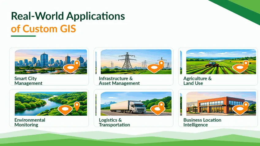
1. Smart City and Urban Infrastructure Management
Cities and urban developments manage numerous infrastructure assets across geographic areas.
Custom GIS can support:
- Infrastructure mapping
- Environmental monitoring
- Streetlight asset management
- Geographic incident visualization
- Urban planning workflows
For example, a Smart City platform may combine GIS with IoT sensor information to display environmental readings and support location-based alerts.
Business value: Better geographic visibility and more coordinated infrastructure operations.
2. Logistics and Fleet Operations
Logistics organizations depend on geographically distributed vehicles, facilities, and delivery destinations.
Custom GIS applications can integrate tracking data, service territories, geographic restrictions, and operational information.
Business value: Improved operational visibility and more informed dispatch decisions.
3. Utilities and Asset Management
Water, electricity, telecommunications, and infrastructure operators can use GIS to manage geographically distributed assets.
Applications may connect asset locations with maintenance histories, equipment conditions, and service territories.
Business value: More structured asset records, geographic analysis, and maintenance planning.
4. Real Estate and Property Development
Property developers and real estate businesses rely on geographic information when evaluating investments.
GIS applications can combine parcel data, transportation accessibility, zoning information, and environmental characteristics.
Business value: Better location-based property assessment and investment analysis.
5. Environmental Monitoring
Environmental organizations may integrate sensor observations, satellite imagery, geographic boundaries, and analytical layers.
Business value: Improved access to geographically contextualized environmental information.
Custom GIS vs. Off-the-Shelf GIS: Which Is Better?
Businesses should evaluate whether customization is necessary before committing to development.
| Factor | Custom GIS | Off-the-Shelf GIS |
|---|---|---|
| Business workflow fit | Can be tailored | Depends on existing features |
| Initial deployment | Usually requires more engineering | Can be faster |
| Specialized integrations | Designed for specific needs | Depends on available APIs |
| User experience | Can be purpose-built | Product-defined |
| Data hosting and control | Architecture-dependent | Vendor/product-dependent |
| Maintenance | Organization or partner responsibility | Often supported by vendor |
| Long-term flexibility | Potentially high | Depends on extensibility and licensing |
A hybrid approach can be effective.
Organizations can use established GIS servers, spatial databases, and mapping libraries while developing only the features and workflows that need customization.
How Much Does Custom GIS Application Development Cost?
There is no standard price for a custom GIS application.
The total cost depends on the complexity of the system.
Major Cost Factors
1. Functional requirements: A simple geographic dashboard is much less complex than a multi-user platform with advanced analysis and editing.
2. Geographic data preparation: Inconsistent coordinate systems, missing data, and complex data conversion can increase project effort.
3. Third-party services: Mapping providers, geocoding APIs, imagery services, and routing engines may involve recurring fees.
4. Enterprise integrations: Connecting GIS with existing business systems requires technical analysis, development, and testing.
5. Security requirements: Sensitive infrastructure or operational data may require additional controls and specialized deployment environments.
6. Performance and scalability: Large geographic datasets may require optimized databases, caching, vector tiles, and distributed processing.
7. Maintenance and support: Hosting, monitoring, updates, and technical support should be included in total cost of ownership.
How to Estimate GIS Development Cost
Instead of starting with an arbitrary fixed budget, organizations should define a clear scope.
A practical estimation process includes identifying core user roles, required workflows, geographic data volumes, external APIs, expected usage, and deployment requirements.
A focused MVP can help validate assumptions before a larger investment.
Seven Steps to Build a Custom GIS Application
Step 1: Define the Business Problem
Identify which decisions or workflows the GIS application needs to support.
Step 2: Review Available Geographic Data
Assess datasets, coordinate reference systems, quality, ownership, and refresh requirements.
Step 3: Define Core Features
Prioritize the capabilities needed for an initial usable version.
Step 4: Design the Technical Architecture
Select spatial storage, geospatial services, frontend technology, backend APIs, and infrastructure.
Step 5: Build a GIS MVP
Develop a limited platform around the most valuable geographic workflows.
Step 6: Test Performance and Accuracy
Validate geographic correctness, coordinate transformations, spatial queries, map rendering, permissions, and usability.
Step 7: Deploy, Monitor, and Improve
Monitor application performance and introduce enhancements based on actual usage and business value.
Common GIS Development Challenges
Geographic Data Quality
Incorrect coordinates and outdated datasets can produce misleading results.
A clear data validation process is essential.
Coordinate Reference Systems
Different datasets may use different coordinate systems.
Incorrect transformations can create geographic alignment errors.
Large Dataset Performance
Complex geographic layers can affect map performance.
Solutions may include spatial indexing, filtering, caching, vector tiles, and data generalization.
System Interoperability
Legacy applications and third-party GIS systems may use different formats or interfaces.
Open standards can reduce integration complexity when appropriately implemented.
Security and Privacy
Geographic systems may contain confidential asset locations or personal information.
Access control, secure APIs, encryption, and appropriate retention policies should be part of system design.
How Custom GIS Can Evolve with AI and IoT
A well-designed GIS architecture can support future capabilities beyond geographic visualization.
GIS and Artificial Intelligence
AI can help classify satellite imagery, identify spatial patterns, or support predictive analysis.
These capabilities are commonly associated with GeoAI.
GIS and IoT
Connected devices can provide updated information about assets, vehicles, infrastructure, or environmental conditions.
GIS provides geographic context for those observations.
GIS and Digital Twins
Geographic data can form part of a digital representation of physical infrastructure.
Combined with relevant operational information and analytical models, GIS can contribute to digital twin applications.
The appropriate expansion path depends on business requirements and data readiness.
Frequently Asked Questions About GIS Application Development
What is custom GIS application development?
Custom GIS application development is the process of building software that manages, analyzes, and visualizes geographic information for specific business needs.
What is the difference between GIS software and a map application?
A map application primarily displays or interacts with locations. GIS software can also support spatial data management, advanced geographic queries, analytical workflows, and specialized enterprise operations.
Which technologies are commonly used for GIS development?
Common options include PostgreSQL/PostGIS, GeoServer, OpenLayers, Leaflet, Mapbox, Python, .NET, Java, and modern web frameworks.
How much does GIS application development cost?
Costs depend on features, data complexity, integrations, third-party services, security, hosting, and maintenance. A scoped discovery process provides a more reliable estimate than a generic fixed price.
Can GIS applications integrate with existing enterprise software?
Yes. GIS applications can exchange data with enterprise systems through compatible APIs, services, and integration pipelines.
Can GIS applications display real-time information?
Yes. They can incorporate frequently updated vehicle, sensor, asset, or operational data when supported by the architecture.
Is custom GIS better than off-the-shelf GIS?
Custom GIS is useful when specialized workflows or integrations are necessary. Off-the-shelf solutions may be more appropriate when standard functionality already satisfies requirements.
Can AI be added to a custom GIS application?
Yes. AI models can support tasks such as imagery classification, spatial prediction, anomaly detection, and geographic decision support.
Conclusion: Build GIS Software Around Business Value
Custom GIS application development helps businesses move beyond basic geographic visualization toward integrated, data-driven operations.
The most effective solutions combine reliable spatial data, suitable architecture, intuitive user interfaces, and clear operational workflows.
Whether an organization is managing infrastructure, optimizing logistics, monitoring the environment, or developing a location-based product, the value of GIS comes from helping people make better decisions.
Rather than starting with technology selection, businesses should begin with the geographic problems they need to solve.
That foundation makes it easier to build scalable, maintainable GIS software aligned with long-term business goals.
Explore Custom GIS Development with BHSoft
Building a custom GIS application requires expertise in spatial data, backend systems, interactive mapping, integration, and application architecture.
At BHSoft, we understand the importance of connecting geographic technology with practical business requirements.
BHSoft's Smart City solution demonstrates an integrated approach combining GIS, IoT, AI, and real-time operational information.
Whether your organization is exploring a custom GIS platform, geospatial data integration, or a location-enabled enterprise application, our team can discuss your development requirements.
Ready to turn geographic data into a practical business solution?
Talk to our team to discuss your GIS software development project.